Arvayheer geodata
Arvayheer (Övörhangay) is a seat of a first-order administrative division; located in Mongolia in Asia/Ulaanbaatar (GMT+8) time zone. With population of 25,622 people, there are 9 cities with bigger population in this country. Compared to other cities in Mongolia, 74.5% of cities are located further ↑North; 51.2% of cities are located further ←West and 82.5% of cities have lower elevation than Arvayheer. Note1


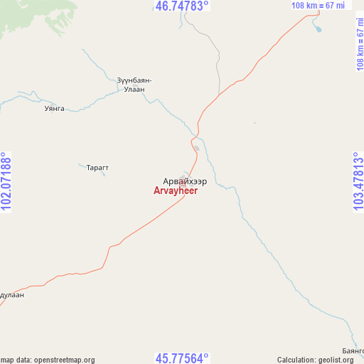
Arvayheer GPS coordinates[2]
46° 15' 50.004" North, 102° 46' 30" East
| Map corner | latitude | longitude |
|---|---|---|
| Upper-left | 46.74783°, | 102.07188° |
| Center: | 46.26389°, | 102.775° |
| Lower-right: | 45.77564°, | 103.47813° |
| Map W x H: | 108.1×108.1 km | = 67.2×67.2mi |
| max Lat: | 51.50725° ⇑74.5% North |
| Arvayheer: | 46.26389° |
| min Lat: | ⇓25.5% South 42.84199° |
| min Long | Arvayheer | max Long |
| 89.14358° | 102.775° | 118.51014° |
| W 51.2%⇐ | ⇒48.8% E |
Elevation
Elevation of Arvayheer is 1838 m = 6030 ft, and this is 421.5 m = 1383 ft above average elevation for this country.
| Max E: |
2800 m = 9186 ft | 17.5% |
| Arvayheer | 1838 m 6030 ft | |
| Avg. | 1416.5 m = 4647 ft | |
Min E: |
619 m = 2031 ft | 82.5% |
See also: Mongolia elevation on elevation.city.
Geographical zone
Arvayheer is located in North temperate zone (between Tropic of Cancer and the Arctic Circle). Distance of this North polar circle is 2257.1 km =1402.5 mi to North.| Distance of | km | miles | from Arvayheer |
|---|---|---|---|
| North Pole | 4863 | 3021.7 | to North |
| Arctic Circle | 2257.1 | 1402.5 | to North |
| Tropic Cancer | 2538.1 | 1577.1 | to South |
| Equator | 5144.1 | 3196.4 | to South |


Nearby cities:
15 places around Arvayheer: (largest is in red/bold)
• Arguut
93.2 km =57.9 mi,  197°
197°
• Bayan-Ulaan
31.8 km =19.8 mi,  334°
334°
• Bumbat
106.2 km =66 mi,  75°
75°
• Harhorin
103.9 km =64.6 mi,  2°
2°
• Hoolt
82.8 km =51.4 mi,  168°
168°
• Hüremt
25.7 km =16 mi,  279°
279°
• Kharkhorin
103.3 km =64.2 mi, 1°
• Khujirt
70.4 km =43.7 mi,  359°
359°
• Mardzad
65.9 km =40.9 mi,  238°
238°
• Mayhan
84.2 km =52.3 mi,  103°
103°
• Mönhbulag
78.4 km =48.7 mi,  46°
46°
• Ongi
43.9 km =27.3 mi,  300°
300°
• Sangiyn Dalay
59.7 km =37.1 mi,  44°
44°
• Shiree
66.7 km =41.4 mi,  133°
133°
• Övt
73.4 km =45.6 mi, 326°
Sources, notices
• [Note1] Compared only with cities in Mongolia existing in our database
• [Src1] Map data: © OpenStreetMap contributors (CC-BY-SA)
• [Src2] Other city data from geonames.org with taken over terms of usage.
• [Src3] Geographical zone / Annual Mean Temperature by Robert A. Rohde @ Wikipedia
