Kharkhorin geodata
Kharkhorin (Övörhangay) is a populated place; located in Mongolia in Asia/Ulaanbaatar (GMT+8) time zone. With population of 8,977 people, there are 26 cities with bigger population in this country. Compared to other cities in Mongolia, 58.6% of cities are located further ↑North; 51.5% of cities are located further ←West and 59.5% of cities have lower elevation than Kharkhorin. Note1


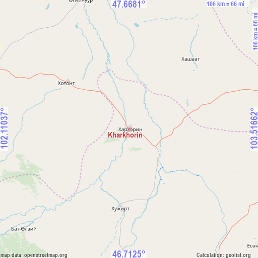
Kharkhorin GPS coordinates[2]
47° 11' 32.82" North, 102° 48' 48.564" East
| Map corner | latitude | longitude |
|---|---|---|
| Upper-left | 47.6681°, | 102.11037° |
| Center: | 47.19245°, | 102.81349° |
| Lower-right: | 46.7125°, | 103.51662° |
| Map W x H: | 106.3×106.3 km | = 66.1×66.1mi |
| max Lat: | 51.50725° ⇑58.6% North |
| Kharkhorin: | 47.19245° |
| min Lat: | ⇓41.4% South 42.84199° |
| min Long | Kharkhorin | max Long |
| 89.14358° | 102.81349° | 118.51014° |
| W 51.5%⇐ | ⇒48.5% E |
Elevation
Elevation of Kharkhorin is 1476 m = 4843 ft, and this is 59.5 m = 195 ft above average elevation for this country.
| Max E: |
2800 m = 9186 ft | 40.5% |
| Kharkhorin | 1476 m 4843 ft | |
| Avg. | 1416.5 m = 4647 ft | |
Min E: |
619 m = 2031 ft | 59.5% |
See also: Mongolia elevation on elevation.city.
Geographical zone
Kharkhorin is located in North temperate zone (between Tropic of Cancer and the Arctic Circle). Distance of this North polar circle is 2153.9 km =1338.4 mi to North.| Distance of | km | miles | from Kharkhorin |
|---|---|---|---|
| North Pole | 4759.8 | 2957.6 | to North |
| Arctic Circle | 2153.9 | 1338.4 | to North |
| Tropic Cancer | 2641.4 | 1641.3 | to South |
| Equator | 5247.3 | 3260.5 | to South |


Nearby cities:
15 places around Kharkhorin: (largest is in red/bold)
• Altan-Ovoo
84.7 km =52.6 mi,  289°
289°
• Avdzaga
72.1 km =44.8 mi,  47°
47°
• Bayan
38.3 km =23.8 mi,  41°
41°
• Bayan-Ulaan
76.4 km =47.5 mi,  192°
192°
• Dzegstey
56.5 km =35.1 mi,  339°
339°
• Harhorin
1 km =0.6 mi, 54°
• Hotont
32.2 km =20 mi,  306°
306°
• Khujirt
33 km =20.5 mi, 185°
• Mönhbulag
72.6 km =45.1 mi,  132°
132°
• Ongi
90.2 km =56 mi,  206°
206°
• Ongon
77.1 km =47.9 mi,  107°
107°
• Sangiyn Dalay
71.4 km =44.4 mi,  147°
147°
• Tavanbulag
71.5 km =44.4 mi, 287°
• Ulaanshiveet
79.5 km =49.4 mi,  82°
82°
• Övt
59.8 km =37.2 mi,  225°
225°
Sources, notices
• [Note1] Compared only with cities in Mongolia existing in our database
• [Src1] Map data: © OpenStreetMap contributors (CC-BY-SA)
• [Src2] Other city data from geonames.org with taken over terms of usage.
• [Src3] Geographical zone / Annual Mean Temperature by Robert A. Rohde @ Wikipedia
