Quatre Cocos geodata
Quatre Cocos (Flacq) is a populated place; located in Mauritius in Indian/Mauritius (GMT+4) time zone. With population of 5,724 people, there are 48 cities with bigger population in this country. Compared to other cities in Mauritius, 56.6% of cities are located further ↓South; 96% of cities are located further ←West and 94.9% of cities have higher elevation than Quatre Cocos. Note1


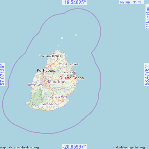
Quatre Cocos GPS coordinates[2]
20° 12' 5.436" South, 57° 46' 28.128" East
| Map corner | latitude | longitude |
|---|---|---|
| Upper-left | -19.54025°, | 57.07136° |
| Center: | -20.20151°, | 57.77448° |
| Lower-right: | -20.85997°, | 58.47761° |
| Map W x H: | 146.7×146.7 km | = 91.2×91.2mi |
| max Lat: | -10.38803° ⇑43.4% North |
| Quatre Cocos: | -20.20151° |
| min Lat: | ⇓56.6% South -20.51667° |
| min Long | Quatre Cocos | max Long |
| 56.61795° | 57.77448° | 63.41667° |
| W 96%⇐ | ⇒4% E |
Elevation
Elevation of Quatre Cocos is 8 m = 26 ft, and this is 144.1 m = 473 ft below average elevation for this country.
| Max E: |
467 m = 1532 ft | 94.9% |
| Avg. | 152.1 m = 499 ft | |
| Quatre Cocos | 8 m = 26 ft | |
Min E: |
1 m = 3 ft | 5.1% |
See also: Mauritius elevation on elevation.city.
Geographical zone
Quatre Cocos is located in South Torrid zone (between Equator and Tropic of Capricorn). Distance of this Southern Tropic circle is 359.7 km =223.5 mi to South.| Distance of | km | miles | from Quatre Cocos |
|---|---|---|---|
| Equator | 2246.2 | 1395.7 | to North |
| Tropic Capricorn | 359.7 | 223.5 | to South |
| Antarctic Circle | 5155 | 3203.2 | to South |
| South Pole | 7760.9 | 4822.4 | to South |


Nearby cities:
15 places around Quatre Cocos: (largest is in red/bold)
• Bel Air Rivière Sèche
6.8 km =4.2 mi,  202°
202°
• Camp Ithier
3.4 km =2.1 mi,  242°
242°
• Camp de Masque
12.2 km =7.6 mi,  251°
251°
• Centre de Flacq
6.4 km =4 mi,  281°
281°
• Clémencia
9.9 km =6.2 mi,  225°
225°
• Ecroignard
4.8 km =3 mi, 235°
• Grande Rivière Sud Est
9.4 km =5.8 mi,  179°
179°
• Lalmatie
11.9 km =7.4 mi, 276°
• Laventure
11.9 km =7.4 mi,  301°
301°
• Mare La Chaux
2.6 km =1.6 mi, 278°
• Olivia
10.6 km =6.6 mi,  205°
205°
• Poste de Flacq
6.3 km =3.9 mi,  313°
313°
• Quatre Soeurs
10.9 km =6.8 mi, 182°
• Queen Victoria
7.3 km =4.5 mi, 253°
• Roches Noire
12 km =7.5 mi,  327°
327°
Sources, notices
• [Note1] Compared only with cities in Mauritius existing in our database
• [Src1] Map data: © OpenStreetMap contributors (CC-BY-SA)
• [Src2] Other city data from geonames.org with taken over terms of usage.
• [Src3] Geographical zone / Annual Mean Temperature by Robert A. Rohde @ Wikipedia
