López Rayón geodata
López Rayón (Tamaulipas) is a populated place; located in Mexico in America/Monterrey (GMT-6) time zone. With population of 1,695 people, there are 5122 cities with bigger population in this country. Compared to other cities in Mexico, 86.7% of cities are located further ↓South; 57.8% of cities are located further ←West and 88% of cities have higher elevation than López Rayón. Note1


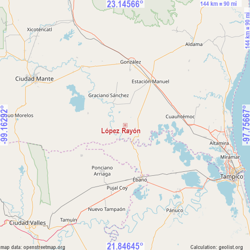
López Rayón GPS coordinates[2]
22° 29' 51.288" North, 98° 27' 35.244" West
| Map corner | latitude | longitude |
|---|---|---|
| Upper-left | 23.14566°, | -99.16292° |
| Center: | 22.49758°, | -98.45979° |
| Lower-right: | 21.84645°, | -97.75667° |
| Map W x H: | 144.5×144.5 km | = 89.8×89.8mi |
| max Lat: | 32.7° ⇑13.3% North |
| López Rayón: | 22.49758° |
| min Lat: | ⇓86.7% South 14.53588° |
| min Long | López Rayón | max Long |
| -117.105° | -98.45979° | -86.73105° |
| W 57.8%⇐ | ⇒42.2% E |
Elevation
Elevation of López Rayón is 30 m = 98 ft, and this is 1223.7 m = 4015 ft below average elevation for this country.
| Max E: |
3497 m = 11473 ft | 88% |
| Avg. | 1253.7 m = 4113 ft | |
| López Rayón | 30 m = 98 ft | |
Min E: |
-1 m = -3 ft | 12% |
See also: Mexico elevation on elevation.city.
Geographical zone
López Rayón is located in North Torrid zone (between Equator and Tropic of Cancer). Distance of this Northern Tropic circle is 104.4 km =64.9 mi to North.| Distance of | km | miles | from López Rayón |
|---|---|---|---|
| North Pole | 7505.6 | 4663.8 | to North |
| Arctic Circle | 4899.7 | 3044.5 | to North |
| Tropic Cancer | 104.4 | 64.9 | to North |
| Equator | 2501.5 | 1554.4 | to South |


Nearby cities:
15 places around López Rayón: (largest is in red/bold)
• Adolfo Ruiz Cortines
13.1 km =8.1 mi,  359°
359°
• Aurelio Manrique
30.5 km =19 mi,  220°
220°
• Colonia Piloto
20.2 km =12.6 mi,  150°
150°
• El Camotero Dos
22.7 km =14.1 mi,  288°
288°
• Graciano Sánchez
20 km =12.4 mi,  330°
330°
• Guayalejo
13 km =8.1 mi,  190°
190°
• Los Aztecas
15.9 km =9.9 mi,  271°
271°
• Magdaleno Aguilar
26.3 km =16.3 mi,  253°
253°
• Nueva Apolonia
17.6 km =10.9 mi, 269°
• Nuevo Tantoán
13.7 km =8.5 mi,  234°
234°
• Ponciano Arriaga
29.4 km =18.3 mi,  207°
207°
• San Antonio Rayón
9.6 km =6 mi, 152°
• Santa Martha
30.6 km =19 mi,  235°
235°
• Tantoyuquita
10.8 km =6.7 mi,  297°
297°
• Ursulo Galván
29.2 km =18.1 mi,  28°
28°
Sources, notices
• [Note1] Compared only with cities in Mexico existing in our database
• [Src1] Map data: © OpenStreetMap contributors (CC-BY-SA)
• [Src2] Other city data from geonames.org with taken over terms of usage.
• [Src3] Geographical zone / Annual Mean Temperature by Robert A. Rohde @ Wikipedia
