Ursulo Galván geodata
Ursulo Galván (Tamaulipas) is a populated place; located in Mexico in America/Monterrey (GMT-6) time zone. With population of 12,077 people, there are 800 cities with bigger population in this country. Compared to other cities in Mexico, 87.4% of cities are located further ↓South; 59.6% of cities are located further ←West and 81.1% of cities have higher elevation than Ursulo Galván. Note1


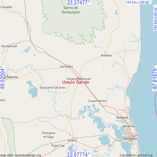
Ursulo Galván GPS coordinates[2]
22° 43' 40.044" North, 98° 19' 18.876" West
| Map corner | latitude | longitude |
|---|---|---|
| Upper-left | 23.37477°, | -99.02504° |
| Center: | 22.72779°, | -98.32191° |
| Lower-right: | 22.07774°, | -97.61879° |
| Map W x H: | 144.2×144.2 km | = 89.6×89.6mi |
| max Lat: | 32.7° ⇑12.6% North |
| Ursulo Galván: | 22.72779° |
| min Lat: | ⇓87.4% South 14.53588° |
| min Long | Ursulo Galván | max Long |
| -117.105° | -98.32191° | -86.73105° |
| W 59.6%⇐ | ⇒40.4% E |
Elevation
Elevation of Ursulo Galván is 80 m = 262 ft, and this is 1173.7 m = 3851 ft below average elevation for this country.
| Max E: |
3497 m = 11473 ft | 81.1% |
| Avg. | 1253.7 m = 4113 ft | |
| Ursulo Galván | 80 m = 262 ft | |
Min E: |
-1 m = -3 ft | 18.9% |
See also: Mexico elevation on elevation.city.
Geographical zone
Ursulo Galván is located in North Torrid zone (between Equator and Tropic of Cancer). Distance of this Northern Tropic circle is 78.8 km =49 mi to North.| Distance of | km | miles | from Ursulo Galván |
|---|---|---|---|
| North Pole | 7480 | 4647.9 | to North |
| Arctic Circle | 4874.1 | 3028.6 | to North |
| Tropic Cancer | 78.8 | 49 | to North |
| Equator | 2527.1 | 1570.3 | to South |


Nearby cities:
15 places around Ursulo Galván: (largest is in red/bold)
• Adolfo Ruiz Cortines
19 km =11.8 mi,  228°
228°
• Aldama
33.2 km =20.6 mi,  49°
49°
• Cuauhtémoc
26.9 km =16.7 mi,  139°
139°
• Esteros
30.6 km =19 mi, 138°
• Francisco I. Madero
25.3 km =15.7 mi,  63°
63°
• González
15.5 km =9.6 mi,  315°
315°
• Graciano Sánchez
25.2 km =15.7 mi,  251°
251°
• Higinio Tanguma
15.6 km =9.7 mi,  26°
26°
• José María Luis Mora
31.7 km =19.7 mi,  115°
115°
• Los Aztecas
39.2 km =24.4 mi, 229°
• López Rayón
29.2 km =18.1 mi,  208°
208°
• Maclovio Herrera
35 km =21.7 mi, 136°
• San Antonio Rayón
35.5 km =22.1 mi,  195°
195°
• Santa Fe
13 km =8.1 mi,  299°
299°
• Tantoyuquita
31.5 km =19.6 mi, 229°
Sources, notices
• [Note1] Compared only with cities in Mexico existing in our database
• [Src1] Map data: © OpenStreetMap contributors (CC-BY-SA)
• [Src2] Other city data from geonames.org with taken over terms of usage.
• [Src3] Geographical zone / Annual Mean Temperature by Robert A. Rohde @ Wikipedia
