Cañada geodata
Cañada (San Luis Potosí) is a populated place; located in Mexico in America/Mexico_City (GMT-6) time zone. With population of 845 people, there are 10356 cities with bigger population in this country. Compared to other cities in Mexico, 84.5% of cities are located further ↓South; 57.6% of cities are located further →East and 51.1% of cities have higher elevation than Cañada. Note1


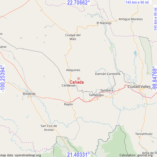
Cañada GPS coordinates[2]
22° 3' 23.292" North, 99° 33' 2.916" West
| Map corner | latitude | longitude |
|---|---|---|
| Upper-left | 22.70662°, | -100.25394° |
| Center: | 22.05647°, | -99.55081° |
| Lower-right: | 21.40331°, | -98.84769° |
| Map W x H: | 144.9×144.9 km | = 90×90mi |
| max Lat: | 32.7° ⇑15.5% North |
| Cañada: | 22.05647° |
| min Lat: | ⇓84.5% South 14.53588° |
| min Long | Cañada | max Long |
| -117.105° | -99.55081° | -86.73105° |
| W 42.4%⇐ | ⇒57.6% E |
Elevation
Elevation of Cañada is 1377 m = 4518 ft, and this is 123.3 m = 405 ft above average elevation for this country.
| Max E: |
3497 m = 11473 ft | 51.1% |
| Cañada | 1377 m 4518 ft | |
| Avg. | 1253.7 m = 4113 ft | |
Min E: |
-1 m = -3 ft | 48.9% |
See also: Mexico elevation on elevation.city.
Geographical zone
Cañada is located in North Torrid zone (between Equator and Tropic of Cancer). Distance of this Northern Tropic circle is 153.5 km =95.4 mi to North.| Distance of | km | miles | from Cañada |
|---|---|---|---|
| North Pole | 7554.6 | 4694.2 | to North |
| Arctic Circle | 4948.7 | 3075 | to North |
| Tropic Cancer | 153.5 | 95.4 | to North |
| Equator | 2452.4 | 1523.9 | to South |


Nearby cities:
15 places around Cañada: (largest is in red/bold)
• Agua Buena
19.5 km =12.1 mi,  124°
124°
• Alaquines
9.6 km =6 mi,  327°
327°
• Cerrito de la Cruz
24.9 km =15.5 mi,  222°
222°
• Colonia Álvaro Obregón
25.2 km =15.7 mi, 329°
• Cárdenas
11.3 km =7 mi,  237°
237°
• Damian Carmona
27 km =16.8 mi,  80°
80°
• El Sabino
3.3 km =2.1 mi,  182°
182°
• Higinio Olivo
9 km =5.6 mi,  199°
199°
• Las Guapas
17.2 km =10.7 mi,  146°
146°
• Martinez
7.8 km =4.8 mi,  279°
279°
• Rancho de Pro
5.2 km =3.2 mi, 327°
• Rayón
25.5 km =15.8 mi, 201°
• San Vicente
24.1 km =15 mi,  245°
245°
• Tamasopo
21.9 km =13.6 mi,  132°
132°
• Tierras Coloradas
18.4 km =11.4 mi,  164°
164°
Sources, notices
• [Note1] Compared only with cities in Mexico existing in our database
• [Src1] Map data: © OpenStreetMap contributors (CC-BY-SA)
• [Src2] Other city data from geonames.org with taken over terms of usage.
• [Src3] Geographical zone / Annual Mean Temperature by Robert A. Rohde @ Wikipedia
