Rayón geodata
Rayón (San Luis Potosí) is a seat of a second-order administrative division; located in Mexico in America/Mexico_City (GMT-6) time zone. With population of 5,928 people, there are 1572 cities with bigger population in this country. Compared to other cities in Mexico, 83.2% of cities are located further ↓South; 59.3% of cities are located further →East and 60.5% of cities have higher elevation than Rayón. Note1


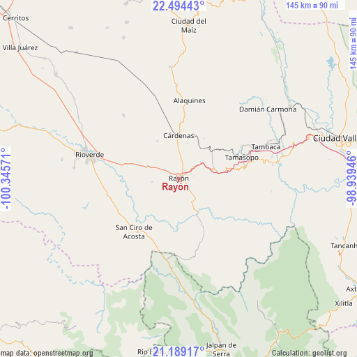
Rayón GPS coordinates[2]
21° 50' 35.844" North, 99° 38' 33.288" West
| Map corner | latitude | longitude |
|---|---|---|
| Upper-left | 22.49443°, | -100.34571° |
| Center: | 21.84329°, | -99.64258° |
| Lower-right: | 21.18917°, | -98.93946° |
| Map W x H: | 145.1×145.1 km | = 90.2×90.2mi |
| max Lat: | 32.7° ⇑16.8% North |
| Rayón: | 21.84329° |
| min Lat: | ⇓83.2% South 14.53588° |
| min Long | Rayón | max Long |
| -117.105° | -99.64258° | -86.73105° |
| W 40.7%⇐ | ⇒59.3% E |
Elevation
Elevation of Rayón is 973 m = 3192 ft, and this is 280.7 m = 921 ft below average elevation for this country.
| Max E: |
3497 m = 11473 ft | 60.5% |
| Avg. | 1253.7 m = 4113 ft | |
| Rayón | 973 m = 3192 ft | |
Min E: |
-1 m = -3 ft | 39.5% |
See also: Mexico elevation on elevation.city.
Geographical zone
Rayón is located in North Torrid zone (between Equator and Tropic of Cancer). Distance of this Northern Tropic circle is 177.2 km =110.1 mi to North.| Distance of | km | miles | from Rayón |
|---|---|---|---|
| North Pole | 7578.3 | 4708.9 | to North |
| Arctic Circle | 4972.4 | 3089.7 | to North |
| Tropic Cancer | 177.2 | 110.1 | to North |
| Equator | 2428.7 | 1509.1 | to South |


Nearby cities:
15 places around Rayón: (largest is in red/bold)
• Cañada
25.5 km =15.8 mi,  21°
21°
• Cerrito de la Cruz
8.9 km =5.5 mi,  306°
306°
• Cuesta Blanca
21.1 km =13.1 mi,  96°
96°
• Cárdenas
17.6 km =10.9 mi,  0°
0°
• El Pajarito
13.4 km =8.3 mi,  194°
194°
• El Puente (Ejido Guayabos)
23.5 km =14.6 mi,  132°
132°
• El Sabino
22.4 km =13.9 mi, 24°
• Higinio Olivo
16.6 km =10.3 mi, 23°
• Ildefonso Turrubiartes (La Boquilla)
25.1 km =15.6 mi,  291°
291°
• Las Guapas
21 km =13 mi,  63°
63°
• Martinez
25 km =15.5 mi, 4°
• Pinihuan
16.5 km =10.3 mi,  152°
152°
• San Vicente
18.6 km =11.6 mi,  317°
317°
• Santa Catarina
25.8 km =16 mi,  143°
143°
• Tierras Coloradas
15.6 km =9.7 mi,  67°
67°
Sources, notices
• [Note1] Compared only with cities in Mexico existing in our database
• [Src1] Map data: © OpenStreetMap contributors (CC-BY-SA)
• [Src2] Other city data from geonames.org with taken over terms of usage.
• [Src3] Geographical zone / Annual Mean Temperature by Robert A. Rohde @ Wikipedia
