Las Guapas geodata
Las Guapas (San Luis Potosí) is a populated place; located in Mexico in America/Mexico_City (GMT-6) time zone. With population of 660 people, there are 13154 cities with bigger population in this country. Compared to other cities in Mexico, 83.7% of cities are located further ↓South; 56.4% of cities are located further →East and 59% of cities have higher elevation than Las Guapas. Note1


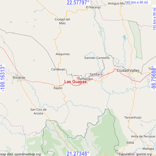
Las Guapas GPS coordinates[2]
21° 55' 37.992" North, 99° 27' 36" West
| Map corner | latitude | longitude |
|---|---|---|
| Upper-left | 22.57797°, | -100.16313° |
| Center: | 21.92722°, | -99.46° |
| Lower-right: | 21.27348°, | -98.75688° |
| Map W x H: | 145×145 km | = 90.1×90.1mi |
| max Lat: | 32.7° ⇑16.3% North |
| Las Guapas: | 21.92722° |
| min Lat: | ⇓83.7% South 14.53588° |
| min Long | Las Guapas | max Long |
| -117.105° | -99.46° | -86.73105° |
| W 43.6%⇐ | ⇒56.4% E |
Elevation
Elevation of Las Guapas is 1054 m = 3458 ft, and this is 199.7 m = 655 ft below average elevation for this country.
| Max E: |
3497 m = 11473 ft | 59% |
| Avg. | 1253.7 m = 4113 ft | |
| Las Guapas | 1054 m = 3458 ft | |
Min E: |
-1 m = -3 ft | 41% |
See also: Mexico elevation on elevation.city.
Geographical zone
Las Guapas is located in North Torrid zone (between Equator and Tropic of Cancer). Distance of this Northern Tropic circle is 167.8 km =104.3 mi to North.| Distance of | km | miles | from Las Guapas |
|---|---|---|---|
| North Pole | 7569 | 4703.2 | to North |
| Arctic Circle | 4963.1 | 3083.9 | to North |
| Tropic Cancer | 167.8 | 104.3 | to North |
| Equator | 2438.1 | 1515 | to South |


Nearby cities:
15 places around Las Guapas: (largest is in red/bold)
• Abras del Corozo
19.2 km =11.9 mi,  89°
89°
• Agua Buena
7.6 km =4.7 mi,  63°
63°
• Cañada
17.2 km =10.7 mi,  326°
326°
• Chino
22.8 km =14.2 mi, 61°
• Cuesta Blanca
12 km =7.5 mi,  170°
170°
• Cárdenas
20.5 km =12.7 mi,  293°
293°
• El Sabino
14.6 km =9.1 mi,  319°
319°
• Higinio Olivo
13.6 km =8.5 mi,  295°
295°
• Martinez
23.1 km =14.4 mi,  312°
312°
• Rancho de Pro
22.3 km =13.9 mi, 327°
• Rascón
21.4 km =13.3 mi,  76°
76°
• Rayón
21 km =13 mi,  243°
243°
• Tamasopo
6.9 km =4.3 mi, 92°
• Tambaca
16.8 km =10.4 mi, 77°
• Tierras Coloradas
5.5 km =3.4 mi,  233°
233°
Sources, notices
• [Note1] Compared only with cities in Mexico existing in our database
• [Src1] Map data: © OpenStreetMap contributors (CC-BY-SA)
• [Src2] Other city data from geonames.org with taken over terms of usage.
• [Src3] Geographical zone / Annual Mean Temperature by Robert A. Rohde @ Wikipedia
