Zacualpan geodata
Zacualpan (State of Mexico) is a seat of a second-order administrative division; located in Mexico in America/Mexico_City (GMT-6) time zone. With population of 2,970 people, there are 3016 cities with bigger population in this country. Compared to other cities in Mexico, 70% of cities are located further ↑North; 61.2% of cities are located further →East and 76.5% of cities have lower elevation than Zacualpan. Note1


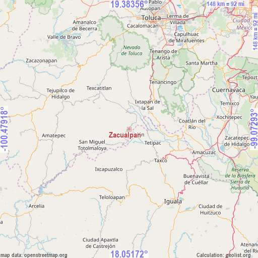
Zacualpan GPS coordinates[2]
18° 43' 8.22" North, 99° 46' 33.78" West
| Map corner | latitude | longitude |
|---|---|---|
| Upper-left | 19.38356°, | -100.47918° |
| Center: | 18.71895°, | -99.77605° |
| Lower-right: | 18.05172°, | -99.07293° |
| Map W x H: | 148.1×148.1 km | = 92×92mi |
| max Lat: | 32.7° ⇑70% North |
| Zacualpan: | 18.71895° |
| min Lat: | ⇓30% South 14.53588° |
| min Long | Zacualpan | max Long |
| -117.105° | -99.77605° | -86.73105° |
| W 38.8%⇐ | ⇒61.2% E |
Elevation
Elevation of Zacualpan is 2057 m = 6749 ft, and this is 803.3 m = 2635 ft above average elevation for this country.
| Max E: |
3497 m = 11473 ft | 23.5% |
| Zacualpan | 2057 m 6749 ft | |
| Avg. | 1253.7 m = 4113 ft | |
Min E: |
-1 m = -3 ft | 76.5% |
See also: Mexico elevation on elevation.city.
Geographical zone
Zacualpan is located in North Torrid zone (between Equator and Tropic of Cancer). Distance of this Northern Tropic circle is 524.6 km =326 mi to North.| Distance of | km | miles | from Zacualpan |
|---|---|---|---|
| North Pole | 7925.7 | 4924.8 | to North |
| Arctic Circle | 5319.8 | 3305.6 | to North |
| Tropic Cancer | 524.6 | 326 | to North |
| Equator | 2081.4 | 1293.3 | to South |


Nearby cities:
15 places around Zacualpan: (largest is in red/bold)
• Ayotuxco
3.8 km =2.4 mi,  312°
312°
• El Refugio
14 km =8.7 mi,  27°
27°
• Huitzoltepec
6 km =3.7 mi,  334°
334°
• Jocotitlán
3.8 km =2.4 mi,  141°
141°
• La Concepción (La Concha)
10.3 km =6.4 mi,  58°
58°
• Llano Grande
12.1 km =7.5 mi,  4°
4°
• Malinaltenango
9.8 km =6.1 mi,  44°
44°
• Mesón Nuevo
11.9 km =7.4 mi, 31°
• Piedra Parada
8 km =5 mi, 33°
• Pilcaya
11.1 km =6.9 mi,  73°
73°
• Plan de Vigas
14.5 km =9 mi, 310°
• Potzontepec
12.5 km =7.8 mi,  279°
279°
• San Alejo
14.2 km =8.8 mi,  20°
20°
• San José Tizates
13.7 km =8.5 mi,  344°
344°
• Tenexcontitlán (El Ranchito)
12.8 km =8 mi,  113°
113°
Sources, notices
• [Note1] Compared only with cities in Mexico existing in our database
• [Src1] Map data: © OpenStreetMap contributors (CC-BY-SA)
• [Src2] Other city data from geonames.org with taken over terms of usage.
• [Src3] Geographical zone / Annual Mean Temperature by Robert A. Rohde @ Wikipedia
