Zacatla geodata
Zacatla (Veracruz) is a populated place; located in Mexico in America/Mexico_City (GMT-6) time zone. With population of 1,830 people, there are 4749 cities with bigger population in this country. Compared to other cities in Mexico, 64.6% of cities are located further ↑North; 73.2% of cities are located further ←West and 79.3% of cities have lower elevation than Zacatla. Note1


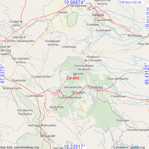
Zacatla GPS coordinates[2]
19° 0' 19.008" North, 97° 8' 3.732" West
| Map corner | latitude | longitude |
|---|---|---|
| Upper-left | 19.66874°, | -97.8375° |
| Center: | 19.00528°, | -97.13437° |
| Lower-right: | 18.33917°, | -96.43125° |
| Map W x H: | 147.8×147.8 km | = 91.8×91.8mi |
| max Lat: | 32.7° ⇑64.6% North |
| Zacatla: | 19.00528° |
| min Lat: | ⇓35.4% South 14.53588° |
| min Long | Zacatla | max Long |
| -117.105° | -97.13437° | -86.73105° |
| W 73.2%⇐ | ⇒26.8% E |
Elevation
Elevation of Zacatla is 2124 m = 6969 ft, and this is 870.3 m = 2855 ft above average elevation for this country.
| Max E: |
3497 m = 11473 ft | 20.7% |
| Zacatla | 2124 m 6969 ft | |
| Avg. | 1253.7 m = 4113 ft | |
Min E: |
-1 m = -3 ft | 79.3% |
See also: Mexico elevation on elevation.city.
Geographical zone
Zacatla is located in North Torrid zone (between Equator and Tropic of Cancer). Distance of this Northern Tropic circle is 492.7 km =306.1 mi to North.| Distance of | km | miles | from Zacatla |
|---|---|---|---|
| North Pole | 7893.9 | 4905 | to North |
| Arctic Circle | 5288 | 3285.8 | to North |
| Tropic Cancer | 492.7 | 306.1 | to North |
| Equator | 2113.2 | 1313.1 | to South |


Nearby cities:
15 places around Zacatla: (largest is in red/bold)
• Chilapa
2.8 km =1.7 mi,  228°
228°
• Contla
5.1 km =3.2 mi,  125°
125°
• Cruz de Chocamán
5.6 km =3.5 mi, 230°
• Cumbre del Español
4 km =2.5 mi,  201°
201°
• El Olvido (San Francisco)
3.4 km =2.1 mi,  38°
38°
• El Zapote
5.3 km =3.3 mi,  190°
190°
• Huilotla
5.5 km =3.4 mi,  63°
63°
• La Lagunilla
2.7 km =1.7 mi,  251°
251°
• Macuilácatl Grande
5.4 km =3.4 mi,  171°
171°
• Metlac Hernández (Metlac Primero)
3.2 km =2 mi, 196°
• Metlac Solano (Metlac Segundo)
2.4 km =1.5 mi,  136°
136°
• Tenixtepec
2.2 km =1.4 mi,  322°
322°
• Teteltzingo
5.2 km =3.2 mi,  348°
348°
• Villa Hermosa
4.6 km =2.9 mi,  214°
214°
• Xocotla
3.7 km =2.3 mi,  72°
72°
Sources, notices
• [Note1] Compared only with cities in Mexico existing in our database
• [Src1] Map data: © OpenStreetMap contributors (CC-BY-SA)
• [Src2] Other city data from geonames.org with taken over terms of usage.
• [Src3] Geographical zone / Annual Mean Temperature by Robert A. Rohde @ Wikipedia
