Xocotla geodata
Xocotla (Veracruz) is a populated place; located in Mexico in America/Mexico_City (GMT-6) time zone. With population of 7,168 people, there are 1294 cities with bigger population in this country. Compared to other cities in Mexico, 64.4% of cities are located further ↑North; 73.6% of cities are located further ←West and 74.1% of cities have lower elevation than Xocotla. Note1


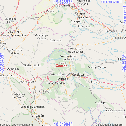
Xocotla GPS coordinates[2]
19° 0' 54.396" North, 97° 6' 3.312" West
| Map corner | latitude | longitude |
|---|---|---|
| Upper-left | 19.67853°, | -97.80405° |
| Center: | 19.01511°, | -97.10092° |
| Lower-right: | 18.34904°, | -96.3978° |
| Map W x H: | 147.8×147.8 km | = 91.8×91.8mi |
| max Lat: | 32.7° ⇑64.4% North |
| Xocotla: | 19.01511° |
| min Lat: | ⇓35.6% South 14.53588° |
| min Long | Xocotla | max Long |
| -117.105° | -97.10092° | -86.73105° |
| W 73.6%⇐ | ⇒26.4% E |
Elevation
Elevation of Xocotla is 2013 m = 6604 ft, and this is 759.3 m = 2491 ft above average elevation for this country.
| Max E: |
3497 m = 11473 ft | 25.9% |
| Xocotla | 2013 m 6604 ft | |
| Avg. | 1253.7 m = 4113 ft | |
Min E: |
-1 m = -3 ft | 74.1% |
See also: Mexico elevation on elevation.city.
Geographical zone
Xocotla is located in North Torrid zone (between Equator and Tropic of Cancer). Distance of this Northern Tropic circle is 491.6 km =305.5 mi to North.| Distance of | km | miles | from Xocotla |
|---|---|---|---|
| North Pole | 7892.8 | 4904.4 | to North |
| Arctic Circle | 5286.9 | 3285.1 | to North |
| Tropic Cancer | 491.6 | 305.5 | to North |
| Equator | 2114.3 | 1313.8 | to South |


Nearby cities:
15 places around Xocotla: (largest is in red/bold)
• Chilapa
6.3 km =3.9 mi,  242°
242°
• Contla
4.1 km =2.5 mi,  170°
170°
• El Olvido (San Francisco)
2.1 km =1.3 mi,  317°
317°
• Huilotla
1.9 km =1.2 mi,  46°
46°
• Ixtayuca (San Nicolás)
5.7 km =3.5 mi,  25°
25°
• La Lagunilla
6.3 km =3.9 mi,  252°
252°
• Metlac Hernández (Metlac Primero)
6.1 km =3.8 mi,  226°
226°
• Metlac Solano (Metlac Segundo)
3.4 km =2.1 mi,  213°
213°
• Rincón Pintor
4.9 km =3 mi,  115°
115°
• Tenixtepec
4.9 km =3 mi,  277°
277°
• Teteltzingo
6.1 km =3.8 mi,  311°
311°
• Tetla
5.2 km =3.2 mi,  126°
126°
• Tetlaxco
4.8 km =3 mi, 54°
• Xonotzintla
6.3 km =3.9 mi,  106°
106°
• Zacatla
3.7 km =2.3 mi, 252°
Sources, notices
• [Note1] Compared only with cities in Mexico existing in our database
• [Src1] Map data: © OpenStreetMap contributors (CC-BY-SA)
• [Src2] Other city data from geonames.org with taken over terms of usage.
• [Src3] Geographical zone / Annual Mean Temperature by Robert A. Rohde @ Wikipedia
