Contla geodata
Contla (Veracruz) is a populated place; located in Mexico in America/Mexico_City (GMT-6) time zone. With population of 884 people, there are 9870 cities with bigger population in this country. Compared to other cities in Mexico, 65.1% of cities are located further ↑North; 73.6% of cities are located further ←West and 56.5% of cities have lower elevation than Contla. Note1


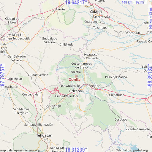
Contla GPS coordinates[2]
18° 58' 42.996" North, 97° 5' 39.984" West
| Map corner | latitude | longitude |
|---|---|---|
| Upper-left | 19.64217°, | -97.79757° |
| Center: | 18.97861°, | -97.09444° |
| Lower-right: | 18.31239°, | -96.39132° |
| Map W x H: | 147.9×147.9 km | = 91.9×91.9mi |
| max Lat: | 32.7° ⇑65.1% North |
| Contla: | 18.97861° |
| min Lat: | ⇓34.9% South 14.53588° |
| min Long | Contla | max Long |
| -117.105° | -97.09444° | -86.73105° |
| W 73.6%⇐ | ⇒26.4% E |
Elevation
Elevation of Contla is 1637 m = 5371 ft, and this is 383.3 m = 1258 ft above average elevation for this country.
| Max E: |
3497 m = 11473 ft | 43.5% |
| Contla | 1637 m 5371 ft | |
| Avg. | 1253.7 m = 4113 ft | |
Min E: |
-1 m = -3 ft | 56.5% |
See also: Mexico elevation on elevation.city.
Geographical zone
Contla is located in North Torrid zone (between Equator and Tropic of Cancer). Distance of this Northern Tropic circle is 495.7 km =308 mi to North.| Distance of | km | miles | from Contla |
|---|---|---|---|
| North Pole | 7896.8 | 4906.8 | to North |
| Arctic Circle | 5291 | 3287.7 | to North |
| Tropic Cancer | 495.7 | 308 | to North |
| Equator | 2110.2 | 1311.2 | to South |


Nearby cities:
15 places around Contla: (largest is in red/bold)
• Cumbre del Español
5.7 km =3.5 mi,  262°
262°
• El Olvido (San Francisco)
6 km =3.7 mi,  339°
339°
• El Zapote
5.6 km =3.5 mi,  246°
246°
• Huilotla
5.4 km =3.4 mi,  7°
7°
• La Sidra
5.2 km =3.2 mi,  162°
162°
• Los Fresnos
6.1 km =3.8 mi,  233°
233°
• Macuilácatl Grande
4.1 km =2.5 mi, 234°
• Metlac Hernández (Metlac Primero)
5.1 km =3.2 mi,  268°
268°
• Metlac Solano (Metlac Segundo)
2.8 km =1.7 mi,  295°
295°
• Rincón Grande
3.7 km =2.3 mi,  185°
185°
• Rincón Pintor
4.2 km =2.6 mi,  62°
62°
• Tetla
3.7 km =2.3 mi,  75°
75°
• Xocotla
4.1 km =2.5 mi,  350°
350°
• Xonotzintla
5.8 km =3.6 mi,  67°
67°
• Zacatla
5.1 km =3.2 mi,  305°
305°
Sources, notices
• [Note1] Compared only with cities in Mexico existing in our database
• [Src1] Map data: © OpenStreetMap contributors (CC-BY-SA)
• [Src2] Other city data from geonames.org with taken over terms of usage.
• [Src3] Geographical zone / Annual Mean Temperature by Robert A. Rohde @ Wikipedia
