Zacapalco geodata
Zacapalco (Guerrero) is a populated place; located in Mexico in America/Mexico_City (GMT-6) time zone. With population of 892 people, there are 9779 cities with bigger population in this country. Compared to other cities in Mexico, 72.2% of cities are located further ↑North; 56.1% of cities are located further →East and 53.7% of cities have higher elevation than Zacapalco. Note1


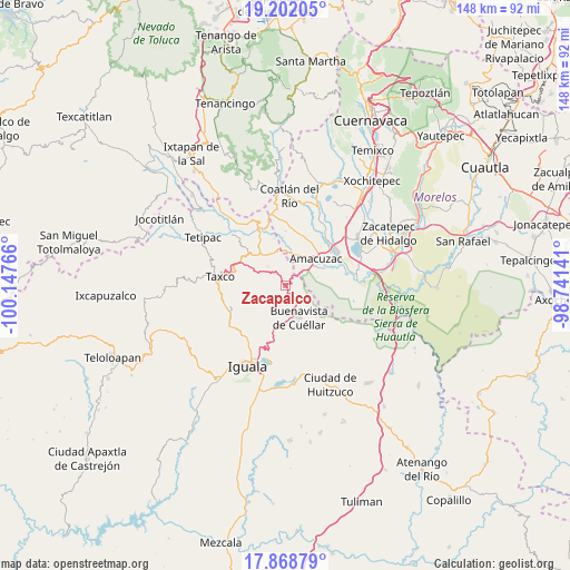
Zacapalco GPS coordinates[2]
18° 32' 12.192" North, 99° 26' 40.308" West
| Map corner | latitude | longitude |
|---|---|---|
| Upper-left | 19.20205°, | -100.14766° |
| Center: | 18.53672°, | -99.44453° |
| Lower-right: | 17.86879°, | -98.74141° |
| Map W x H: | 148.2×148.2 km | = 92.1×92.1mi |
| max Lat: | 32.7° ⇑72.2% North |
| Zacapalco: | 18.53672° |
| min Lat: | ⇓27.8% South 14.53588° |
| min Long | Zacapalco | max Long |
| -117.105° | -99.44453° | -86.73105° |
| W 43.9%⇐ | ⇒56.1% E |
Elevation
Elevation of Zacapalco is 1258 m = 4127 ft, and this is 4.3 m = 14 ft above average elevation for this country.
| Max E: |
3497 m = 11473 ft | 53.7% |
| Zacapalco | 1258 m 4127 ft | |
| Avg. | 1253.7 m = 4113 ft | |
Min E: |
-1 m = -3 ft | 46.3% |
See also: Mexico elevation on elevation.city.
Geographical zone
Zacapalco is located in North Torrid zone (between Equator and Tropic of Cancer). Distance of this Northern Tropic circle is 544.8 km =338.5 mi to North.| Distance of | km | miles | from Zacapalco |
|---|---|---|---|
| North Pole | 7946 | 4937.4 | to North |
| Arctic Circle | 5340.1 | 3318.2 | to North |
| Tropic Cancer | 544.8 | 338.5 | to North |
| Equator | 2061.1 | 1280.7 | to South |


Nearby cities:
15 places around Zacapalco: (largest is in red/bold)
• Amacuzac
10.5 km =6.5 mi,  48°
48°
• Axixintla
10.6 km =6.6 mi,  313°
313°
• Buenavista de Cuéllar
9.4 km =5.8 mi,  156°
156°
• Cajones
11.2 km =7 mi,  67°
67°
• Casahuatlán
7 km =4.3 mi, 54°
• Coahuixtla
8.9 km =5.5 mi,  62°
62°
• Coxcatlán
4.9 km =3 mi,  199°
199°
• Huajintlán
8.3 km =5.2 mi,  14°
14°
• Miahuatlán (El Cuiji)
11.3 km =7 mi, 58°
• Palmillas
2.6 km =1.6 mi,  129°
129°
• Rancho Nuevo
8.2 km =5.1 mi,  78°
78°
• Santa Fe Tepetlapa
2.5 km =1.6 mi, 56°
• Teacalco
9 km =5.6 mi,  354°
354°
• Texcaltitla
6.6 km =4.1 mi,  317°
317°
• Tlamacazapa
7.4 km =4.6 mi,  232°
232°
Sources, notices
• [Note1] Compared only with cities in Mexico existing in our database
• [Src1] Map data: © OpenStreetMap contributors (CC-BY-SA)
• [Src2] Other city data from geonames.org with taken over terms of usage.
• [Src3] Geographical zone / Annual Mean Temperature by Robert A. Rohde @ Wikipedia
