Coahuixtla geodata
Coahuixtla (Morelos) is a populated place; located in Mexico in America/Mexico_City (GMT-6) time zone. With population of 1,046 people, there are 8327 cities with bigger population in this country. Compared to other cities in Mexico, 71.7% of cities are located further ↑North; 55.2% of cities are located further →East and 61.1% of cities have higher elevation than Coahuixtla. Note1


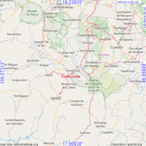
Coahuixtla GPS coordinates[2]
18° 34' 27.012" North, 99° 22' 12" West
| Map corner | latitude | longitude |
|---|---|---|
| Upper-left | 19.23935°, | -100.07313° |
| Center: | 18.57417°, | -99.37° |
| Lower-right: | 17.90638°, | -98.66688° |
| Map W x H: | 148.2×148.2 km | = 92.1×92.1mi |
| max Lat: | 32.7° ⇑71.7% North |
| Coahuixtla: | 18.57417° |
| min Lat: | ⇓28.3% South 14.53588° |
| min Long | Coahuixtla | max Long |
| -117.105° | -99.37° | -86.73105° |
| W 44.8%⇐ | ⇒55.2% E |
Elevation
Elevation of Coahuixtla is 929 m = 3048 ft, and this is 324.7 m = 1065 ft below average elevation for this country.
| Max E: |
3497 m = 11473 ft | 61.1% |
| Avg. | 1253.7 m = 4113 ft | |
| Coahuixtla | 929 m = 3048 ft | |
Min E: |
-1 m = -3 ft | 38.9% |
See also: Mexico elevation on elevation.city.
Geographical zone
Coahuixtla is located in North Torrid zone (between Equator and Tropic of Cancer). Distance of this Northern Tropic circle is 540.7 km =336 mi to North.| Distance of | km | miles | from Coahuixtla |
|---|---|---|---|
| North Pole | 7941.8 | 4934.8 | to North |
| Arctic Circle | 5335.9 | 3315.6 | to North |
| Tropic Cancer | 540.7 | 336 | to North |
| Equator | 2065.3 | 1283.3 | to South |


Nearby cities:
15 places around Coahuixtla: (largest is in red/bold)
• 24 de Febrero
8.3 km =5.2 mi,  32°
32°
• Amacuzac
2.7 km =1.7 mi,  1°
1°
• Cajones
2.5 km =1.6 mi,  88°
88°
• Casahuatlán
2.2 km =1.4 mi,  265°
265°
• El Coco
6.3 km =3.9 mi,  73°
73°
• El Estudiante
7.7 km =4.8 mi, 87°
• Huajintlán
6.9 km =4.3 mi,  304°
304°
• Miahuatlán (El Cuiji)
2.5 km =1.6 mi,  44°
44°
• Palmillas
8.2 km =5.1 mi,  225°
225°
• Puente de Ixtla
7.1 km =4.4 mi,  50°
50°
• Rancho Nuevo
2.6 km =1.6 mi,  175°
175°
• San Gabriel las Palmas
5.1 km =3.2 mi, 28°
• Santa Fe Tepetlapa
6.4 km =4 mi,  244°
244°
• Teacalco
9.9 km =6.2 mi, 298°
• Zacapalco
8.9 km =5.5 mi, 242°
Sources, notices
• [Note1] Compared only with cities in Mexico existing in our database
• [Src1] Map data: © OpenStreetMap contributors (CC-BY-SA)
• [Src2] Other city data from geonames.org with taken over terms of usage.
• [Src3] Geographical zone / Annual Mean Temperature by Robert A. Rohde @ Wikipedia
