Teacalco geodata
Teacalco (Morelos) is a populated place; located in Mexico in America/Mexico_City (GMT-6) time zone. With population of 761 people, there are 11509 cities with bigger population in this country. Compared to other cities in Mexico, 71.2% of cities are located further ↑North; 56.2% of cities are located further →East and 60.1% of cities have higher elevation than Teacalco. Note1


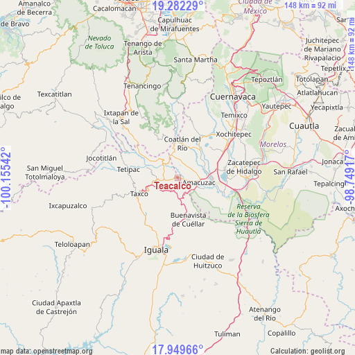
Teacalco GPS coordinates[2]
18° 37' 2.208" North, 99° 27' 8.244" West
| Map corner | latitude | longitude |
|---|---|---|
| Upper-left | 19.28229°, | -100.15542° |
| Center: | 18.61728°, | -99.45229° |
| Lower-right: | 17.94966°, | -98.74917° |
| Map W x H: | 148.2×148.2 km | = 92.1×92.1mi |
| max Lat: | 32.7° ⇑71.2% North |
| Teacalco: | 18.61728° |
| min Lat: | ⇓28.8% South 14.53588° |
| min Long | Teacalco | max Long |
| -117.105° | -99.45229° | -86.73105° |
| W 43.8%⇐ | ⇒56.2% E |
Elevation
Elevation of Teacalco is 995 m = 3264 ft, and this is 258.7 m = 849 ft below average elevation for this country.
| Max E: |
3497 m = 11473 ft | 60.1% |
| Avg. | 1253.7 m = 4113 ft | |
| Teacalco | 995 m = 3264 ft | |
Min E: |
-1 m = -3 ft | 39.9% |
See also: Mexico elevation on elevation.city.
Geographical zone
Teacalco is located in North Torrid zone (between Equator and Tropic of Cancer). Distance of this Northern Tropic circle is 535.9 km =333 mi to North.| Distance of | km | miles | from Teacalco |
|---|---|---|---|
| North Pole | 7937 | 4931.8 | to North |
| Arctic Circle | 5331.1 | 3312.6 | to North |
| Tropic Cancer | 535.9 | 333 | to North |
| Equator | 2070 | 1286.2 | to South |


Nearby cities:
15 places around Teacalco: (largest is in red/bold)
• Acuitlapan
9.7 km =6 mi,  259°
259°
• Amacuzac
9 km =5.6 mi,  103°
103°
• Apancingo
7 km =4.3 mi,  350°
350°
• Axixintla
7.1 km =4.4 mi, 256°
• Cacahuamilpa
9.1 km =5.7 mi,  321°
321°
• Casahuatlán
8.2 km =5.1 mi,  127°
127°
• Coahuixtla
9.9 km =6.2 mi,  118°
118°
• Cuauchichinola
9.6 km =6 mi,  57°
57°
• Huajintlán
3.1 km =1.9 mi,  106°
106°
• La Joya
5.7 km =3.5 mi,  344°
344°
• Michapa
9.9 km =6.2 mi, 343°
• San José el Potrero
3.8 km =2.4 mi,  327°
327°
• Santa Fe Tepetlapa
8.1 km =5 mi,  158°
158°
• Texcaltitla
5.5 km =3.4 mi,  221°
221°
• Zacapalco
9 km =5.6 mi,  174°
174°
Sources, notices
• [Note1] Compared only with cities in Mexico existing in our database
• [Src1] Map data: © OpenStreetMap contributors (CC-BY-SA)
• [Src2] Other city data from geonames.org with taken over terms of usage.
• [Src3] Geographical zone / Annual Mean Temperature by Robert A. Rohde @ Wikipedia
