Coxcatlán geodata
Coxcatlán (Guerrero) is a populated place; located in Mexico in America/Mexico_City (GMT-6) time zone. With population of 845 people, there are 10356 cities with bigger population in this country. Compared to other cities in Mexico, 72.7% of cities are located further ↑North; 56.3% of cities are located further →East and 59% of cities have lower elevation than Coxcatlán. Note1


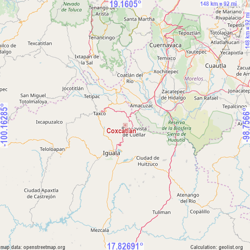
Coxcatlán GPS coordinates[2]
18° 29' 42" North, 99° 27' 34.992" West
| Map corner | latitude | longitude |
|---|---|---|
| Upper-left | 19.1605°, | -100.16285° |
| Center: | 18.495°, | -99.45972° |
| Lower-right: | 17.82691°, | -98.7566° |
| Map W x H: | 148.3×148.3 km | = 92.1×92.1mi |
| max Lat: | 32.7° ⇑72.7% North |
| Coxcatlán: | 18.495° |
| min Lat: | ⇓27.3% South 14.53588° |
| min Long | Coxcatlán | max Long |
| -117.105° | -99.45972° | -86.73105° |
| W 43.7%⇐ | ⇒56.3% E |
Elevation
Elevation of Coxcatlán is 1707 m = 5600 ft, and this is 453.3 m = 1487 ft above average elevation for this country.
| Max E: |
3497 m = 11473 ft | 41% |
| Coxcatlán | 1707 m 5600 ft | |
| Avg. | 1253.7 m = 4113 ft | |
Min E: |
-1 m = -3 ft | 59% |
See also: Mexico elevation on elevation.city.
Geographical zone
Coxcatlán is located in North Torrid zone (between Equator and Tropic of Cancer). Distance of this Northern Tropic circle is 549.5 km =341.4 mi to North.| Distance of | km | miles | from Coxcatlán |
|---|---|---|---|
| North Pole | 7950.6 | 4940.3 | to North |
| Arctic Circle | 5344.7 | 3321 | to North |
| Tropic Cancer | 549.5 | 341.4 | to North |
| Equator | 2056.5 | 1277.8 | to South |


Nearby cities:
15 places around Coxcatlán: (largest is in red/bold)
• Buenavista de Cuéllar
6.7 km =4.2 mi,  126°
126°
• Casahuatlán
11.3 km =7 mi,  40°
40°
• Coahuixtla
12.9 km =8 mi,  47°
47°
• El Naranjo
13.2 km =8.2 mi,  216°
216°
• Huajintlán
13.2 km =8.2 mi,  16°
16°
• Juliantla
11.3 km =7 mi,  296°
296°
• Mexcaltepec
12.4 km =7.7 mi,  226°
226°
• Palmillas
4.7 km =2.9 mi, 50°
• Rancho Nuevo
11.5 km =7.1 mi,  57°
57°
• San Juan de Dios (Naranjas de Dios)
11.8 km =7.3 mi, 300°
• Santa Fe Tepetlapa
7.1 km =4.4 mi,  31°
31°
• Taxco el Viejo
13.2 km =8.2 mi,  264°
264°
• Texcaltitla
9.9 km =6.2 mi,  343°
343°
• Tlamacazapa
4.3 km =2.7 mi,  272°
272°
• Zacapalco
4.9 km =3 mi, 19°
Sources, notices
• [Note1] Compared only with cities in Mexico existing in our database
• [Src1] Map data: © OpenStreetMap contributors (CC-BY-SA)
• [Src2] Other city data from geonames.org with taken over terms of usage.
• [Src3] Geographical zone / Annual Mean Temperature by Robert A. Rohde @ Wikipedia
