Zacacuautla geodata
Zacacuautla (Hidalgo) is a populated place; located in Mexico in America/Mexico_City (GMT-6) time zone. With population of 1,317 people, there are 6586 cities with bigger population in this country. Compared to other cities in Mexico, 61.7% of cities are located further ↓South; 60.8% of cities are located further ←West and 82.5% of cities have lower elevation than Zacacuautla. Note1


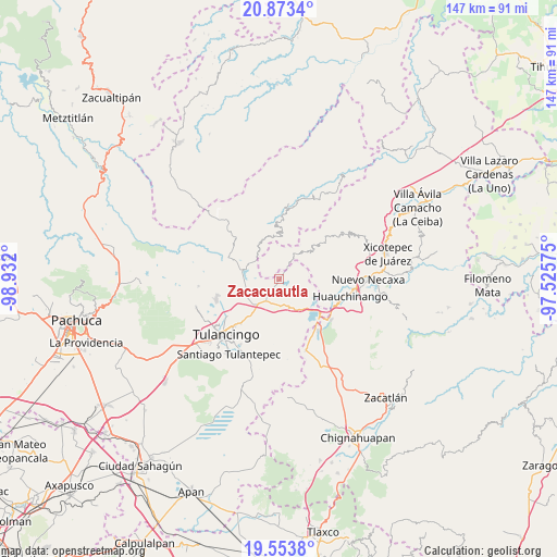
Zacacuautla GPS coordinates[2]
20° 12' 54" North, 98° 13' 43.932" West
| Map corner | latitude | longitude |
|---|---|---|
| Upper-left | 20.8734°, | -98.932° |
| Center: | 20.215°, | -98.22887° |
| Lower-right: | 19.5538°, | -97.52575° |
| Map W x H: | 146.7×146.7 km | = 91.2×91.2mi |
| max Lat: | 32.7° ⇑38.3% North |
| Zacacuautla: | 20.215° |
| min Lat: | ⇓61.7% South 14.53588° |
| min Long | Zacacuautla | max Long |
| -117.105° | -98.22887° | -86.73105° |
| W 60.8%⇐ | ⇒39.2% E |
Elevation
Elevation of Zacacuautla is 2200 m = 7218 ft, and this is 946.3 m = 3105 ft above average elevation for this country.
| Max E: |
3497 m = 11473 ft | 17.5% |
| Zacacuautla | 2200 m 7218 ft | |
| Avg. | 1253.7 m = 4113 ft | |
Min E: |
-1 m = -3 ft | 82.5% |
See also: Mexico elevation on elevation.city.
Geographical zone
Zacacuautla is located in North Torrid zone (between Equator and Tropic of Cancer). Distance of this Northern Tropic circle is 358.2 km =222.6 mi to North.| Distance of | km | miles | from Zacacuautla |
|---|---|---|---|
| North Pole | 7759.4 | 4821.5 | to North |
| Arctic Circle | 5153.5 | 3202.2 | to North |
| Tropic Cancer | 358.2 | 222.6 | to North |
| Equator | 2247.7 | 1396.7 | to South |


Nearby cities:
15 places around Zacacuautla: (largest is in red/bold)
• Acaxochitlán
7 km =4.3 mi,  155°
155°
• Amapoloa
3.3 km =2.1 mi,  9°
9°
• Barrio Cuaunepantla
6.5 km =4 mi,  179°
179°
• Barrio Techachalco
6 km =3.7 mi,  165°
165°
• Chila de Juárez
7.6 km =4.7 mi,  15°
15°
• Honey
3.2 km =2 mi,  32°
32°
• La Cumbre del Manzano
4.4 km =2.7 mi, 19°
• La Magdalena
6.7 km =4.2 mi,  313°
313°
• San Mateo
4 km =2.5 mi,  207°
207°
• San Miguel del Resgate
5.8 km =3.6 mi,  75°
75°
• San Pedro Tlachichilco
7 km =4.3 mi, 211°
• Santa Ana Tzacuala
3.2 km =2 mi,  126°
126°
• Tlacpac
7.5 km =4.7 mi, 170°
• Tlatzintla
7.7 km =4.8 mi,  147°
147°
• Tonalixco
3.3 km =2.1 mi,  303°
303°
Sources, notices
• [Note1] Compared only with cities in Mexico existing in our database
• [Src1] Map data: © OpenStreetMap contributors (CC-BY-SA)
• [Src2] Other city data from geonames.org with taken over terms of usage.
• [Src3] Geographical zone / Annual Mean Temperature by Robert A. Rohde @ Wikipedia
