San Mateo geodata
San Mateo (Hidalgo) is a populated place; located in Mexico in America/Mexico_City (GMT-6) time zone. With population of 2,222 people, there are 3950 cities with bigger population in this country. Compared to other cities in Mexico, 61% of cities are located further ↓South; 60.6% of cities are located further ←West and 86.4% of cities have lower elevation than San Mateo. Note1


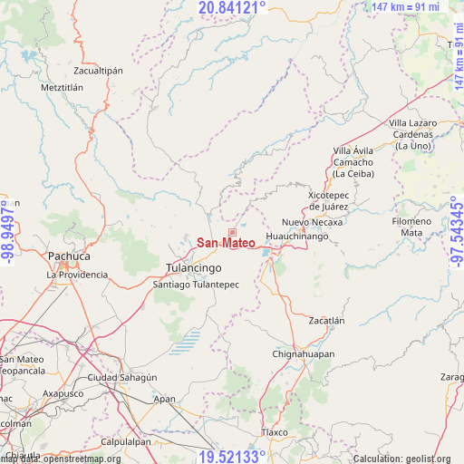
San Mateo GPS coordinates[2]
20° 10' 57.612" North, 98° 14' 47.652" West
| Map corner | latitude | longitude |
|---|---|---|
| Upper-left | 20.84121°, | -98.9497° |
| Center: | 20.18267°, | -98.24657° |
| Lower-right: | 19.52133°, | -97.54345° |
| Map W x H: | 146.8×146.8 km | = 91.2×91.2mi |
| max Lat: | 32.7° ⇑39% North |
| San Mateo: | 20.18267° |
| min Lat: | ⇓61% South 14.53588° |
| min Long | San Mateo | max Long |
| -117.105° | -98.24657° | -86.73105° |
| W 60.6%⇐ | ⇒39.4% E |
Elevation
Elevation of San Mateo is 2291 m = 7516 ft, and this is 1037.3 m = 3403 ft above average elevation for this country.
| Max E: |
3497 m = 11473 ft | 13.6% |
| San Mateo | 2291 m 7516 ft | |
| Avg. | 1253.7 m = 4113 ft | |
Min E: |
-1 m = -3 ft | 86.4% |
See also: Mexico elevation on elevation.city.
Geographical zone
San Mateo is located in North Torrid zone (between Equator and Tropic of Cancer). Distance of this Northern Tropic circle is 361.8 km =224.8 mi to North.| Distance of | km | miles | from San Mateo |
|---|---|---|---|
| North Pole | 7763 | 4823.7 | to North |
| Arctic Circle | 5157.1 | 3204.5 | to North |
| Tropic Cancer | 361.8 | 224.8 | to North |
| Equator | 2244.1 | 1394.4 | to South |


Nearby cities:
15 places around San Mateo: (largest is in red/bold)
• Acaxochitlán
5.4 km =3.4 mi,  120°
120°
• Amapoloa
7.3 km =4.5 mi,  19°
19°
• Barrio Cuaunepantla
3.5 km =2.2 mi,  145°
145°
• Barrio Techachalco
4 km =2.5 mi, 123°
• Honey
7.2 km =4.5 mi,  29°
29°
• San Pedro Tlachichilco
3 km =1.9 mi,  217°
217°
• Santa Ana Hueytlalpan
6.9 km =4.3 mi,  262°
262°
• Santa Ana Tzacuala
4.8 km =3 mi,  69°
69°
• Santa María Asunción
3.9 km =2.4 mi, 218°
• Tepaltzingo
6.1 km =3.8 mi, 216°
• Tlacpac
4.9 km =3 mi,  140°
140°
• Tlaltegco (Venta Quemada)
7.1 km =4.4 mi,  126°
126°
• Tlatzintla
6.6 km =4.1 mi, 116°
• Tonalixco
5.5 km =3.4 mi,  350°
350°
• Zacacuautla
4 km =2.5 mi, 27°
Sources, notices
• [Note1] Compared only with cities in Mexico existing in our database
• [Src1] Map data: © OpenStreetMap contributors (CC-BY-SA)
• [Src2] Other city data from geonames.org with taken over terms of usage.
• [Src3] Geographical zone / Annual Mean Temperature by Robert A. Rohde @ Wikipedia
