Xhitey geodata
Xhitey (State of Mexico) is a populated place; located in Mexico in America/Mexico_City (GMT-6) time zone. With population of 1,189 people, there are 7304 cities with bigger population in this country. Compared to other cities in Mexico, 56.6% of cities are located further ↓South; 57.3% of cities are located further →East and 90.8% of cities have lower elevation than Xhitey. Note1


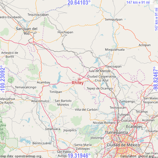
Xhitey GPS coordinates[2]
19° 58' 53.868" North, 99° 31' 40.044" West
| Map corner | latitude | longitude |
|---|---|---|
| Upper-left | 20.64103°, | -100.23092° |
| Center: | 19.98163°, | -99.52779° |
| Lower-right: | 19.31946°, | -98.82467° |
| Map W x H: | 146.9×146.9 km | = 91.3×91.3mi |
| max Lat: | 32.7° ⇑43.4% North |
| Xhitey: | 19.98163° |
| min Lat: | ⇓56.6% South 14.53588° |
| min Long | Xhitey | max Long |
| -117.105° | -99.52779° | -86.73105° |
| W 42.7%⇐ | ⇒57.3% E |
Elevation
Elevation of Xhitey is 2435 m = 7989 ft, and this is 1181.3 m = 3876 ft above average elevation for this country.
| Max E: |
3497 m = 11473 ft | 9.2% |
| Xhitey | 2435 m 7989 ft | |
| Avg. | 1253.7 m = 4113 ft | |
Min E: |
-1 m = -3 ft | 90.8% |
See also: Mexico elevation on elevation.city.
Geographical zone
Xhitey is located in North Torrid zone (between Equator and Tropic of Cancer). Distance of this Northern Tropic circle is 384.2 km =238.7 mi to North.| Distance of | km | miles | from Xhitey |
|---|---|---|---|
| North Pole | 7785.3 | 4837.6 | to North |
| Arctic Circle | 5179.4 | 3218.3 | to North |
| Tropic Cancer | 384.2 | 238.7 | to North |
| Equator | 2221.7 | 1380.5 | to South |


Nearby cities:
15 places around Xhitey: (largest is in red/bold)
• Agua Escondida
5.3 km =3.3 mi,  266°
266°
• Coscomate del Progreso
5.4 km =3.4 mi,  170°
170°
• Dexcani Bajo
4.7 km =2.9 mi,  143°
143°
• Ejido de Coscomate del Progreso
5.7 km =3.5 mi,  200°
200°
• El Huisache (Tercera Manzana de Dexcani Alto)
5.7 km =3.5 mi,  132°
132°
• El Magueyal
6.5 km =4 mi,  228°
228°
• Jilotepec de Molina Enríquez
3.3 km =2.1 mi,  188°
188°
• La Comunidad
6.7 km =4.2 mi,  311°
311°
• Las Huertas
3.1 km =1.9 mi,  250°
250°
• Las Manzanas
4.9 km =3 mi, 225°
• Octeyuco Dos Mil
6.6 km =4.1 mi, 252°
• Ojo de Agua
6.2 km =3.9 mi,  100°
100°
• San Pablo Huantepec
3.8 km =2.4 mi,  89°
89°
• Soyaniquilpan
3.7 km =2.3 mi,  356°
356°
• Xhixhata
2.3 km =1.4 mi,  237°
237°
Sources, notices
• [Note1] Compared only with cities in Mexico existing in our database
• [Src1] Map data: © OpenStreetMap contributors (CC-BY-SA)
• [Src2] Other city data from geonames.org with taken over terms of usage.
• [Src3] Geographical zone / Annual Mean Temperature by Robert A. Rohde @ Wikipedia
