X-Cán geodata
X-Cán (Yucatán) is a populated place; located in Mexico in America/Merida (GMT-6) time zone. With population of 5,191 people, there are 1784 cities with bigger population in this country. Compared to other cities in Mexico, 74.1% of cities are located further ↓South; 99.8% of cities are located further ←West and 90.8% of cities have higher elevation than X-Cán. Note1


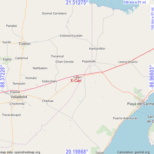
X-Cán GPS coordinates[2]
20° 51' 25.74" North, 87° 40' 8.94" West
| Map corner | latitude | longitude |
|---|---|---|
| Upper-left | 21.51275°, | -88.37228° |
| Center: | 20.85715°, | -87.66915° |
| Lower-right: | 20.19868°, | -86.96603° |
| Map W x H: | 146.1×146.1 km | = 90.8×90.8mi |
| max Lat: | 32.7° ⇑25.9% North |
| X-Cán: | 20.85715° |
| min Lat: | ⇓74.1% South 14.53588° |
| min Long | X-Cán | max Long |
| -117.105° | -87.66915° | -86.73105° |
| W 99.8%⇐ | ⇒0.2% E |
Elevation
Elevation of X-Cán is 22 m = 72 ft, and this is 1231.7 m = 4041 ft below average elevation for this country.
| Max E: |
3497 m = 11473 ft | 90.8% |
| Avg. | 1253.7 m = 4113 ft | |
| X-Cán | 22 m = 72 ft | |
Min E: |
-1 m = -3 ft | 9.2% |
See also: Mexico elevation on elevation.city.
Geographical zone
X-Cán is located in North Torrid zone (between Equator and Tropic of Cancer). Distance of this Northern Tropic circle is 286.8 km =178.2 mi to North.| Distance of | km | miles | from X-Cán |
|---|---|---|---|
| North Pole | 7688 | 4777.1 | to North |
| Arctic Circle | 5082.1 | 3157.9 | to North |
| Tropic Cancer | 286.8 | 178.2 | to North |
| Equator | 2319.1 | 1441 | to South |


Nearby cities:
15 places around X-Cán: (largest is in red/bold)
• Chan Cenote
19.2 km =11.9 mi,  320°
320°
• Chechmil
32.1 km =19.9 mi,  252°
252°
• Cocoyol
11.2 km =7 mi,  229°
229°
• El Cedral
16.1 km =10 mi,  49°
49°
• El Ideal
13.2 km =8.2 mi,  78°
78°
• El Tintal
21.4 km =13.3 mi, 79°
• Ignacio Zaragoza
15.2 km =9.4 mi, 79°
• Kantunilkín
33.2 km =20.6 mi,  34°
34°
• Kuxeb
20.8 km =12.9 mi,  270°
270°
• Nuevo Xcán
7 km =4.3 mi, 78°
• Popolnah
18.8 km =11.7 mi,  36°
36°
• San Francisco
17.7 km =11 mi,  103°
103°
• Tixcancal
27.4 km =17 mi, 316°
• Vicente Guerrero
23.1 km =14.4 mi, 52°
• Xmuquel
18.1 km =11.2 mi,  283°
283°
Sources, notices
• [Note1] Compared only with cities in Mexico existing in our database
• [Src1] Map data: © OpenStreetMap contributors (CC-BY-SA)
• [Src2] Other city data from geonames.org with taken over terms of usage.
• [Src3] Geographical zone / Annual Mean Temperature by Robert A. Rohde @ Wikipedia
