Nuevo Xcán geodata
Nuevo Xcán (Quintana Roo) is a populated place; located in Mexico in America/Cancun (GMT-5) time zone. With population of 1,130 people, there are 7675 cities with bigger population in this country. Compared to other cities in Mexico, 74.3% of cities are located further ↓South; 99.8% of cities are located further ←West and 90% of cities have higher elevation than Nuevo Xcán. Note1


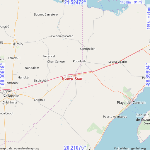
Nuevo Xcán GPS coordinates[2]
20° 52' 9.012" North, 87° 36' 11.016" West
| Map corner | latitude | longitude |
|---|---|---|
| Upper-left | 21.52472°, | -88.30619° |
| Center: | 20.86917°, | -87.60306° |
| Lower-right: | 20.21075°, | -86.89994° |
| Map W x H: | 146.1×146.1 km | = 90.8×90.8mi |
| max Lat: | 32.7° ⇑25.7% North |
| Nuevo Xcán: | 20.86917° |
| min Lat: | ⇓74.3% South 14.53588° |
| min Long | Nuevo Xcán | max Long |
| -117.105° | -87.60306° | -86.73105° |
| W 99.8%⇐ | ⇒0.2% E |
Elevation
Elevation of Nuevo Xcán is 24 m = 79 ft, and this is 1229.7 m = 4034 ft below average elevation for this country.
| Max E: |
3497 m = 11473 ft | 90% |
| Avg. | 1253.7 m = 4113 ft | |
| Nuevo Xcán | 24 m = 79 ft | |
Min E: |
-1 m = -3 ft | 10% |
See also: Mexico elevation on elevation.city.
Geographical zone
Nuevo Xcán is located in North Torrid zone (between Equator and Tropic of Cancer). Distance of this Northern Tropic circle is 285.5 km =177.4 mi to North.| Distance of | km | miles | from Nuevo Xcán |
|---|---|---|---|
| North Pole | 7686.6 | 4776.2 | to North |
| Arctic Circle | 5080.7 | 3157 | to North |
| Tropic Cancer | 285.5 | 177.4 | to North |
| Equator | 2320.4 | 1441.8 | to South |


Nearby cities:
15 places around Nuevo Xcán: (largest is in red/bold)
• Chan Cenote
23.3 km =14.5 mi,  305°
305°
• Chechmil
39.1 km =24.3 mi,  254°
254°
• Cocoyol
17.6 km =10.9 mi,  240°
240°
• El Cedral
10.6 km =6.6 mi,  30°
30°
• El Ideal
6.2 km =3.9 mi,  77°
77°
• El Tintal
14.5 km =9 mi, 79°
• Ignacio Zaragoza
8.2 km =5.1 mi, 80°
• Kantunilkín
28.6 km =17.8 mi, 25°
• Kuxeb
27.7 km =17.2 mi,  267°
267°
• Popolnah
14.4 km =8.9 mi,  16°
16°
• San Francisco
11.6 km =7.2 mi,  117°
117°
• Tixcancal
31.7 km =19.7 mi, 305°
• Vicente Guerrero
17.1 km =10.6 mi,  42°
42°
• X-Cán
7 km =4.3 mi,  258°
258°
• Xmuquel
24.6 km =15.3 mi,  277°
277°
Sources, notices
• [Note1] Compared only with cities in Mexico existing in our database
• [Src1] Map data: © OpenStreetMap contributors (CC-BY-SA)
• [Src2] Other city data from geonames.org with taken over terms of usage.
• [Src3] Geographical zone / Annual Mean Temperature by Robert A. Rohde @ Wikipedia
