El Ideal geodata
El Ideal (Quintana Roo) is a populated place; located in Mexico in America/Cancun (GMT-5) time zone. With population of 818 people, there are 10682 cities with bigger population in this country. Compared to other cities in Mexico, 74.5% of cities are located further ↓South; 99.9% of cities are located further ←West and 91.2% of cities have higher elevation than El Ideal. Note1


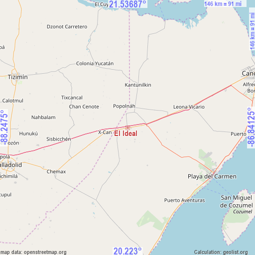
El Ideal GPS coordinates[2]
20° 52' 52.932" North, 87° 32' 39.732" West
| Map corner | latitude | longitude |
|---|---|---|
| Upper-left | 21.53687°, | -88.2475° |
| Center: | 20.88137°, | -87.54437° |
| Lower-right: | 20.223°, | -86.84125° |
| Map W x H: | 146.1×146.1 km | = 90.8×90.8mi |
| max Lat: | 32.7° ⇑25.5% North |
| El Ideal: | 20.88137° |
| min Lat: | ⇓74.5% South 14.53588° |
| min Long | El Ideal | max Long |
| -117.105° | -87.54437° | -86.73105° |
| W 99.9%⇐ | ⇒0.099999999999994% E |
Elevation
Elevation of El Ideal is 21 m = 69 ft, and this is 1232.7 m = 4044 ft below average elevation for this country.
| Max E: |
3497 m = 11473 ft | 91.2% |
| Avg. | 1253.7 m = 4113 ft | |
| El Ideal | 21 m = 69 ft | |
Min E: |
-1 m = -3 ft | 8.8% |
See also: Mexico elevation on elevation.city.
Geographical zone
El Ideal is located in North Torrid zone (between Equator and Tropic of Cancer). Distance of this Northern Tropic circle is 284.1 km =176.5 mi to North.| Distance of | km | miles | from El Ideal |
|---|---|---|---|
| North Pole | 7685.3 | 4775.4 | to North |
| Arctic Circle | 5079.4 | 3156.2 | to North |
| Tropic Cancer | 284.1 | 176.5 | to North |
| Equator | 2321.8 | 1442.7 | to South |


Nearby cities:
15 places around El Ideal: (largest is in red/bold)
• Chan Cenote
27.9 km =17.3 mi,  296°
296°
• Cocoyol
23.6 km =14.7 mi,  244°
244°
• El Cedral
7.8 km =4.8 mi,  355°
355°
• El Tintal
8.2 km =5.1 mi,  81°
81°
• Ignacio Zaragoza
2 km =1.2 mi,  89°
89°
• Kantunilkín
25.2 km =15.7 mi,  13°
13°
• Kuxeb
33.9 km =21.1 mi,  265°
265°
• Leona Vicario
37.5 km =23.3 mi,  71°
71°
• Nuevo Xcán
6.2 km =3.9 mi,  257°
257°
• Popolnah
12.6 km =7.8 mi,  351°
351°
• San Francisco
8 km =5 mi,  147°
147°
• Tixcancal
36.1 km =22.4 mi, 298°
• Vicente Guerrero
12.5 km =7.8 mi,  25°
25°
• X-Cán
13.2 km =8.2 mi, 258°
• Xmuquel
30.5 km =19 mi, 273°
Sources, notices
• [Note1] Compared only with cities in Mexico existing in our database
• [Src1] Map data: © OpenStreetMap contributors (CC-BY-SA)
• [Src2] Other city data from geonames.org with taken over terms of usage.
• [Src3] Geographical zone / Annual Mean Temperature by Robert A. Rohde @ Wikipedia
