Popolnah geodata
Popolnah (Yucatán) is a populated place; located in Mexico in America/Merida (GMT-6) time zone. With population of 3,276 people, there are 2769 cities with bigger population in this country. Compared to other cities in Mexico, 76.4% of cities are located further ↓South; 99.9% of cities are located further ←West and 93% of cities have higher elevation than Popolnah. Note1


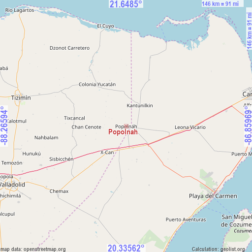
Popolnah GPS coordinates[2]
20° 59' 36.6" North, 87° 33' 46.116" West
| Map corner | latitude | longitude |
|---|---|---|
| Upper-left | 21.6485°, | -88.26594° |
| Center: | 20.9935°, | -87.56281° |
| Lower-right: | 20.33562°, | -86.85969° |
| Map W x H: | 146×146 km | = 90.7×90.7mi |
| max Lat: | 32.7° ⇑23.6% North |
| Popolnah: | 20.9935° |
| min Lat: | ⇓76.4% South 14.53588° |
| min Long | Popolnah | max Long |
| -117.105° | -87.56281° | -86.73105° |
| W 99.9%⇐ | ⇒0.099999999999994% E |
Elevation
Elevation of Popolnah is 17 m = 56 ft, and this is 1236.7 m = 4057 ft below average elevation for this country.
| Max E: |
3497 m = 11473 ft | 93% |
| Avg. | 1253.7 m = 4113 ft | |
| Popolnah | 17 m = 56 ft | |
Min E: |
-1 m = -3 ft | 7% |
See also: Mexico elevation on elevation.city.
Geographical zone
Popolnah is located in North Torrid zone (between Equator and Tropic of Cancer). Distance of this Northern Tropic circle is 271.7 km =168.8 mi to North.| Distance of | km | miles | from Popolnah |
|---|---|---|---|
| North Pole | 7672.8 | 4767.7 | to North |
| Arctic Circle | 5066.9 | 3148.4 | to North |
| Tropic Cancer | 271.7 | 168.8 | to North |
| Equator | 2334.3 | 1450.5 | to South |


Nearby cities:
15 places around Popolnah: (largest is in red/bold)
• Chan Cenote
23.1 km =14.4 mi,  269°
269°
• Cocoyol
29.7 km =18.5 mi,  220°
220°
• Colonia Yucatán
29.6 km =18.4 mi,  325°
325°
• El Cedral
4.9 km =3 mi,  165°
165°
• El Ideal
12.6 km =7.8 mi, 171°
• El Tintal
15.1 km =9.4 mi,  138°
138°
• Ignacio Zaragoza
13 km =8.1 mi,  162°
162°
• Kantunilkín
14.4 km =8.9 mi,  33°
33°
• Nuevo Xcán
14.4 km =8.9 mi,  196°
196°
• San Angel
30.1 km =18.7 mi, 26°
• San Francisco
20.2 km =12.6 mi, 162°
• Tixcancal
30.2 km =18.8 mi,  278°
278°
• Vicente Guerrero
7.4 km =4.6 mi,  99°
99°
• X-Cán
18.8 km =11.7 mi, 216°
• Xmuquel
30.5 km =19 mi,  249°
249°
Sources, notices
• [Note1] Compared only with cities in Mexico existing in our database
• [Src1] Map data: © OpenStreetMap contributors (CC-BY-SA)
• [Src2] Other city data from geonames.org with taken over terms of usage.
• [Src3] Geographical zone / Annual Mean Temperature by Robert A. Rohde @ Wikipedia
