El Volador geodata
El Volador (Veracruz) is a populated place; located in Mexico in America/Mexico_City (GMT-6) time zone. With population of 2,343 people, there are 3767 cities with bigger population in this country. Compared to other cities in Mexico, 70.8% of cities are located further ↓South; 72% of cities are located further ←West and 82.6% of cities have higher elevation than El Volador. Note1


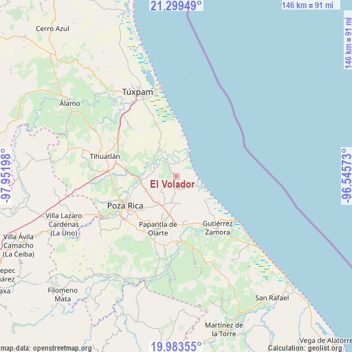
El Volador GPS coordinates[2]
20° 38' 34.584" North, 97° 14' 55.86" West
| Map corner | latitude | longitude |
|---|---|---|
| Upper-left | 21.29949°, | -97.95198° |
| Center: | 20.64294°, | -97.24885° |
| Lower-right: | 19.98355°, | -96.54573° |
| Map W x H: | 146.3×146.3 km | = 90.9×90.9mi |
| max Lat: | 32.7° ⇑29.2% North |
| El Volador: | 20.64294° |
| min Lat: | ⇓70.8% South 14.53588° |
| min Long | El Volador | max Long |
| -117.105° | -97.24885° | -86.73105° |
| W 72%⇐ | ⇒28% E |
Elevation
Elevation of El Volador is 64 m = 210 ft, and this is 1189.7 m = 3903 ft below average elevation for this country.
| Max E: |
3497 m = 11473 ft | 82.6% |
| Avg. | 1253.7 m = 4113 ft | |
| El Volador | 64 m = 210 ft | |
Min E: |
-1 m = -3 ft | 17.4% |
See also: Mexico elevation on elevation.city.
Geographical zone
El Volador is located in North Torrid zone (between Equator and Tropic of Cancer). Distance of this Northern Tropic circle is 310.6 km =193 mi to North.| Distance of | km | miles | from El Volador |
|---|---|---|---|
| North Pole | 7711.8 | 4791.9 | to North |
| Arctic Circle | 5105.9 | 3172.7 | to North |
| Tropic Cancer | 310.6 | 193 | to North |
| Equator | 2295.3 | 1426.2 | to South |


Nearby cities:
15 places around El Volador: (largest is in red/bold)
• Adolfo Ruíz Cortines
7.9 km =4.9 mi,  228°
228°
• Barrio Acosta Lagunes
8.9 km =5.5 mi,  310°
310°
• Buenavista
7.6 km =4.7 mi,  32°
32°
• Cabellal Número Uno
8.6 km =5.3 mi,  295°
295°
• Caristay
5.9 km =3.7 mi,  272°
272°
• Carrizal
5.3 km =3.3 mi,  188°
188°
• Cazones de Herrera
9.3 km =5.8 mi,  316°
316°
• Cruz Blanca Número Uno
3.1 km =1.9 mi,  264°
264°
• La Encantada
9.8 km =6.1 mi,  351°
351°
• Limón Chiquito
5.4 km =3.4 mi, 319°
• Plan de Limón
3.2 km =2 mi, 307°
• Poza Verde
7.8 km =4.8 mi,  182°
182°
• Puente de Piedra
6.9 km =4.3 mi,  127°
127°
• Rancho Nuevo
5.5 km =3.4 mi,  53°
53°
• Tenixtepec
9.8 km =6.1 mi,  141°
141°
Sources, notices
• [Note1] Compared only with cities in Mexico existing in our database
• [Src1] Map data: © OpenStreetMap contributors (CC-BY-SA)
• [Src2] Other city data from geonames.org with taken over terms of usage.
• [Src3] Geographical zone / Annual Mean Temperature by Robert A. Rohde @ Wikipedia
