Tenixtepec geodata
Tenixtepec (Veracruz) is a populated place; located in Mexico in America/Mexico_City (GMT-6) time zone. With population of 597 people, there are 14400 cities with bigger population in this country. Compared to other cities in Mexico, 69.4% of cities are located further ↓South; 72.6% of cities are located further ←West and 84.7% of cities have higher elevation than Tenixtepec. Note1


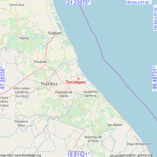
Tenixtepec GPS coordinates[2]
20° 34' 26.04" North, 97° 11' 25.548" West
| Map corner | latitude | longitude |
|---|---|---|
| Upper-left | 21.23075°, | -97.89356° |
| Center: | 20.5739°, | -97.19043° |
| Lower-right: | 19.91421°, | -96.48731° |
| Map W x H: | 146.4×146.4 km | = 91×91mi |
| max Lat: | 32.7° ⇑30.6% North |
| Tenixtepec: | 20.5739° |
| min Lat: | ⇓69.4% South 14.53588° |
| min Long | Tenixtepec | max Long |
| -117.105° | -97.19043° | -86.73105° |
| W 72.6%⇐ | ⇒27.4% E |
Elevation
Elevation of Tenixtepec is 46 m = 151 ft, and this is 1207.7 m = 3962 ft below average elevation for this country.
| Max E: |
3497 m = 11473 ft | 84.7% |
| Avg. | 1253.7 m = 4113 ft | |
| Tenixtepec | 46 m = 151 ft | |
Min E: |
-1 m = -3 ft | 15.3% |
See also: Mexico elevation on elevation.city.
Geographical zone
Tenixtepec is located in North Torrid zone (between Equator and Tropic of Cancer). Distance of this Northern Tropic circle is 318.3 km =197.8 mi to North.| Distance of | km | miles | from Tenixtepec |
|---|---|---|---|
| North Pole | 7719.5 | 4796.7 | to North |
| Arctic Circle | 5113.6 | 3177.4 | to North |
| Tropic Cancer | 318.3 | 197.8 | to North |
| Equator | 2287.6 | 1421.4 | to South |


Nearby cities:
15 places around Tenixtepec: (largest is in red/bold)
• Adolfo Ruíz Cortines
12.3 km =7.6 mi,  281°
281°
• Boca de Lima
6 km =3.7 mi,  109°
109°
• Carrizal
7.3 km =4.5 mi,  289°
289°
• Cruz Blanca Número Uno
11.8 km =7.3 mi,  308°
308°
• El Cedro
10.8 km =6.7 mi,  189°
189°
• El Volador
9.8 km =6.1 mi,  321°
321°
• Hermenegildo Galeana
12.7 km =7.9 mi,  163°
163°
• La Guásima
7.2 km =4.5 mi,  238°
238°
• Plan de Limón
13 km =8.1 mi, 318°
• Polutla
8.8 km =5.5 mi,  234°
234°
• Poza Verde
6.5 km =4 mi,  269°
269°
• Puente de Piedra
3.6 km =2.2 mi,  350°
350°
• Rancho Nuevo
11.1 km =6.9 mi, 351°
• San Pablo
12.4 km =7.7 mi,  180°
180°
• Santa Águeda
13.3 km =8.3 mi,  258°
258°
Sources, notices
• [Note1] Compared only with cities in Mexico existing in our database
• [Src1] Map data: © OpenStreetMap contributors (CC-BY-SA)
• [Src2] Other city data from geonames.org with taken over terms of usage.
• [Src3] Geographical zone / Annual Mean Temperature by Robert A. Rohde @ Wikipedia
