Adolfo Ruíz Cortines geodata
Adolfo Ruíz Cortines (Veracruz) is a populated place; located in Mexico in America/Mexico_City (GMT-6) time zone. With population of 1,828 people, there are 4757 cities with bigger population in this country. Compared to other cities in Mexico, 69.9% of cities are located further ↓South; 71.5% of cities are located further ←West and 84.7% of cities have higher elevation than Adolfo Ruíz Cortines. Note1
Current local time in Adolfo Ruíz Cortines:
06:52 AM, WednesdayDifference from your time zone: hours


Adolfo Ruíz Cortines GPS coordinates[2]
20° 35' 45.06" North, 97° 18' 21.06" West
| Map corner | latitude | longitude |
|---|---|---|
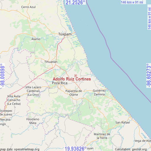
| Upper-left | 21.2526°, | -98.00898° |
| Center: | 20.59585°, | -97.30585° |
| Lower-right: | 19.93626°, | -96.60273° |
| Map W x H: | 146.4×146.4 km | = 91×91mi |
| max Lat: | 32.7° ⇑30.1% North |
| Adolfo Ruíz Cortines: | 20.59585° |
| min Lat: | ⇓69.9% South 14.53588° |
| min Long | Adolfo Ruíz Co | max Long |
| -117.105° | -97.30585° | -86.73105° |
| W 71.5%⇐ | ⇒28.5% E |
Elevation
Elevation of Adolfo Ruíz Cortines is 46 m = 151 ft, and this is 1207.7 m = 3962 ft below average elevation for this country.
| Max E: |
3497 m = 11473 ft | 84.7% |
| Avg. | 1253.7 m = 4113 ft | |
| Adolfo Ruíz Cortines | 46 m = 151 ft | |
Min E: |
-1 m = -3 ft | 15.3% |
See also: Mexico elevation on elevation.city.
Geographical zone
Adolfo Ruíz Cortines is located in North Torrid zone (between Equator and Tropic of Cancer). Distance of this Northern Tropic circle is 315.9 km =196.3 mi to North.| Distance of | km | miles | from Adolfo Ruíz Cortines |
|---|---|---|---|
| North Pole | 7717 | 4795.1 | to North |
| Arctic Circle | 5111.1 | 3175.9 | to North |
| Tropic Cancer | 315.9 | 196.3 | to North |
| Equator | 2290 | 1422.9 | to South |


Nearby cities:
15 places around Adolfo Ruíz Cortines: (largest is in red/bold)
• Cabellal Número Uno
9.1 km =5.7 mi,  347°
347°
• Caristay
5.5 km =3.4 mi,  359°
359°
• Carrizal
5.1 km =3.2 mi,  90°
90°
• Cruz Blanca Número Uno
5.7 km =3.5 mi,  29°
29°
• El Cabellal
7.9 km =4.9 mi,  226°
226°
• El Volador
7.9 km =4.9 mi,  48°
48°
• La Guásima
8.6 km =5.3 mi,  136°
136°
• Limón Chiquito
9.7 km =6 mi,  14°
14°
• Plan de Limón
8 km =5 mi, 25°
• Plan de los Mangos
5.1 km =3.2 mi,  218°
218°
• Polutla
9 km =5.6 mi,  147°
147°
• Poza Verde
6.1 km =3.8 mi,  114°
114°
• Santa Águeda
5.2 km =3.2 mi,  191°
191°
• Sombrerete
3.1 km =1.9 mi,  279°
279°
• Vicente Herrera
5 km =3.1 mi,  245°
245°
Sources, notices
• [Note1] Compared only with cities in Mexico existing in our database
• [Src1] Map data: © OpenStreetMap contributors (CC-BY-SA)
• [Src2] Other city data from geonames.org with taken over terms of usage.
• [Src3] Geographical zone / Annual Mean Temperature by Robert A. Rohde @ Wikipedia
