Buenos Aires geodata
Buenos Aires (Veracruz) is a populated place; located in Mexico in America/Mexico_City (GMT-6) time zone. With population of 525 people, there are 16085 cities with bigger population in this country. Compared to other cities in Mexico, 66% of cities are located further ↑North; 77.7% of cities are located further ←West and 68.9% of cities have higher elevation than Buenos Aires. Note1


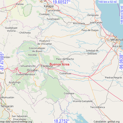
Buenos Aires GPS coordinates[2]
18° 56' 29.616" North, 96° 46' 0.912" West
| Map corner | latitude | longitude |
|---|---|---|
| Upper-left | 19.60527°, | -97.47005° |
| Center: | 18.94156°, | -96.76692° |
| Lower-right: | 18.2752°, | -96.0638° |
| Map W x H: | 147.9×147.9 km | = 91.9×91.9mi |
| max Lat: | 32.7° ⇑66% North |
| Buenos Aires: | 18.94156° |
| min Lat: | ⇓34% South 14.53588° |
| min Long | Buenos Aires | max Long |
| -117.105° | -96.76692° | -86.73105° |
| W 77.7%⇐ | ⇒22.3% E |
Elevation
Elevation of Buenos Aires is 476 m = 1562 ft, and this is 777.7 m = 2552 ft below average elevation for this country.
| Max E: |
3497 m = 11473 ft | 68.9% |
| Avg. | 1253.7 m = 4113 ft | |
| Buenos Aires | 476 m = 1562 ft | |
Min E: |
-1 m = -3 ft | 31.1% |
See also: Mexico elevation on elevation.city.
Geographical zone
Buenos Aires is located in North Torrid zone (between Equator and Tropic of Cancer). Distance of this Northern Tropic circle is 499.8 km =310.6 mi to North.| Distance of | km | miles | from Buenos Aires |
|---|---|---|---|
| North Pole | 7901 | 4909.5 | to North |
| Arctic Circle | 5295.1 | 3290.2 | to North |
| Tropic Cancer | 499.8 | 310.6 | to North |
| Equator | 2106.1 | 1308.7 | to South |


Nearby cities:
15 places around Buenos Aires: (largest is in red/bold)
• Atoyac
3.5 km =2.2 mi,  200°
200°
• Cañada Blanca
9.4 km =5.8 mi,  277°
277°
• Cerro Azul
7.7 km =4.8 mi,  334°
334°
• Corral de Piedra
9.6 km =6 mi,  176°
176°
• Ejido la Piña (Maromilla)
9.8 km =6.1 mi,  349°
349°
• Ejido los Naranjos
10 km =6.2 mi,  286°
286°
• General Miguel Alemán
6 km =3.7 mi,  206°
206°
• Ignacio Zaragoza
7.6 km =4.7 mi,  249°
249°
• La Charca
5.4 km =3.4 mi,  302°
302°
• Mata Naranjo
7.1 km =4.4 mi,  2°
2°
• Palo Gacho
10.5 km =6.5 mi,  335°
335°
• Paso del Macho
5.6 km =3.5 mi,  53°
53°
• Progreso
9.2 km =5.7 mi,  314°
314°
• Salvador Esquer Apodaca [Unidad Habitacional]
5.2 km =3.2 mi,  70°
70°
• San José Balsa Camarón
6.6 km =4.1 mi,  95°
95°
Sources, notices
• [Note1] Compared only with cities in Mexico existing in our database
• [Src1] Map data: © OpenStreetMap contributors (CC-BY-SA)
• [Src2] Other city data from geonames.org with taken over terms of usage.
• [Src3] Geographical zone / Annual Mean Temperature by Robert A. Rohde @ Wikipedia
