Villa del Carbón geodata
Villa del Carbón (State of Mexico) is a seat of a second-order administrative division; located in Mexico in America/Mexico_City (GMT-6) time zone. With population of 8,778 people, there are 1084 cities with bigger population in this country. Compared to other cities in Mexico, 51.1% of cities are located further ↓South; 56.4% of cities are located further →East and 95.2% of cities have lower elevation than Villa del Carbón. Note1


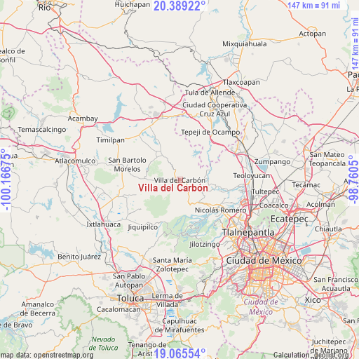
Villa del Carbón GPS coordinates[2]
19° 43' 43.5" North, 99° 27' 49.032" West
| Map corner | latitude | longitude |
|---|---|---|
| Upper-left | 20.38922°, | -100.16675° |
| Center: | 19.72875°, | -99.46362° |
| Lower-right: | 19.06554°, | -98.7605° |
| Map W x H: | 147.2×147.2 km | = 91.5×91.5mi |
| max Lat: | 32.7° ⇑48.9% North |
| Villa del Carbón: | 19.72875° |
| min Lat: | ⇓51.1% South 14.53588° |
| min Long | Villa del Carb� | max Long |
| -117.105° | -99.46362° | -86.73105° |
| W 43.6%⇐ | ⇒56.4% E |
Elevation
Elevation of Villa del Carbón is 2600 m = 8530 ft, and this is 1346.3 m = 4417 ft above average elevation for this country.
| Max E: |
3497 m = 11473 ft | 4.8% |
| Villa del Carbón | 2600 m 8530 ft | |
| Avg. | 1253.7 m = 4113 ft | |
Min E: |
-1 m = -3 ft | 95.2% |
See also: Mexico elevation on elevation.city.
Geographical zone
Villa del Carbón is located in North Torrid zone (between Equator and Tropic of Cancer). Distance of this Northern Tropic circle is 412.3 km =256.2 mi to North.| Distance of | km | miles | from Villa del Carbón |
|---|---|---|---|
| North Pole | 7813.4 | 4855 | to North |
| Arctic Circle | 5207.5 | 3235.8 | to North |
| Tropic Cancer | 412.3 | 256.2 | to North |
| Equator | 2193.6 | 1363 | to South |


Nearby cities:
15 places around Villa del Carbón: (largest is in red/bold)
• El Cerrito
6.2 km =3.9 mi,  217°
217°
• El Ocotal
5.5 km =3.4 mi,  187°
187°
• La Capilla
5.8 km =3.6 mi,  273°
273°
• La Esperanza
7.4 km =4.6 mi,  227°
227°
• Llano de Zacapexco
3.5 km =2.2 mi, 219°
• Loma Alta
4.6 km =2.9 mi,  160°
160°
• Los Arana
4.6 km =2.9 mi,  242°
242°
• Los Barbechos
5.7 km =3.5 mi,  202°
202°
• Monte de Peña
8.8 km =5.5 mi, 272°
• San Francisco de las Tablas
8 km =5 mi,  301°
301°
• San Isidro del Bosque
9 km =5.6 mi, 201°
• San Juan de las Tablas
7.6 km =4.7 mi,  144°
144°
• San Lucas
2 km =1.2 mi,  153°
153°
• San Luis Anáhuac (Toriles)
10.1 km =6.3 mi,  41°
41°
• San Martín Cachihuapan
4.1 km =2.5 mi,  124°
124°
Sources, notices
• [Note1] Compared only with cities in Mexico existing in our database
• [Src1] Map data: © OpenStreetMap contributors (CC-BY-SA)
• [Src2] Other city data from geonames.org with taken over terms of usage.
• [Src3] Geographical zone / Annual Mean Temperature by Robert A. Rohde @ Wikipedia
