San Lucas geodata
San Lucas (State of Mexico) is a populated place; located in Mexico in America/Mexico_City (GMT-6) time zone. With population of 622 people, there are 13890 cities with bigger population in this country. Compared to other cities in Mexico, 50.7% of cities are located further ↓South; 56.3% of cities are located further →East and 95.9% of cities have lower elevation than San Lucas. Note1


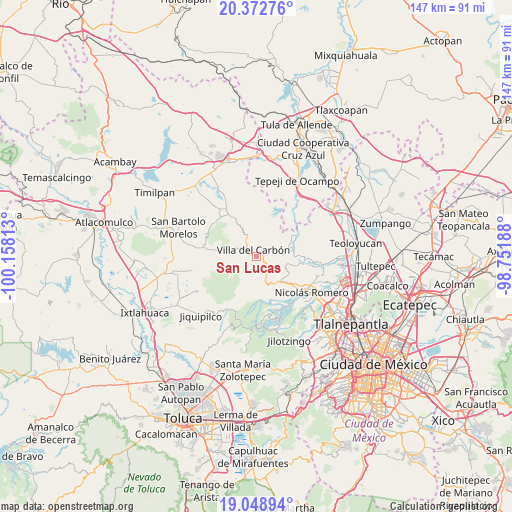
San Lucas GPS coordinates[2]
19° 42' 43.992" North, 99° 27' 18" West
| Map corner | latitude | longitude |
|---|---|---|
| Upper-left | 20.37276°, | -100.15813° |
| Center: | 19.71222°, | -99.455° |
| Lower-right: | 19.04894°, | -98.75188° |
| Map W x H: | 147.2×147.2 km | = 91.5×91.5mi |
| max Lat: | 32.7° ⇑49.3% North |
| San Lucas: | 19.71222° |
| min Lat: | ⇓50.7% South 14.53588° |
| min Long | San Lucas | max Long |
| -117.105° | -99.455° | -86.73105° |
| W 43.7%⇐ | ⇒56.3% E |
Elevation
Elevation of San Lucas is 2623 m = 8606 ft, and this is 1369.3 m = 4492 ft above average elevation for this country.
| Max E: |
3497 m = 11473 ft | 4.1% |
| San Lucas | 2623 m 8606 ft | |
| Avg. | 1253.7 m = 4113 ft | |
Min E: |
-1 m = -3 ft | 95.9% |
See also: Mexico elevation on elevation.city.
Geographical zone
San Lucas is located in North Torrid zone (between Equator and Tropic of Cancer). Distance of this Northern Tropic circle is 414.1 km =257.3 mi to North.| Distance of | km | miles | from San Lucas |
|---|---|---|---|
| North Pole | 7815.3 | 4856.2 | to North |
| Arctic Circle | 5209.4 | 3237 | to North |
| Tropic Cancer | 414.1 | 257.3 | to North |
| Equator | 2191.8 | 1361.9 | to South |


Nearby cities:
15 places around San Lucas: (largest is in red/bold)
• El Cerrito
5.6 km =3.5 mi,  236°
236°
• El Ocotal
3.9 km =2.4 mi,  203°
203°
• La Capilla
7 km =4.3 mi,  288°
288°
• La Esperanza
7.1 km =4.4 mi, 243°
• Llano de Zacapexco
3.3 km =2.1 mi,  253°
253°
• Loma Alta
2.6 km =1.6 mi,  166°
166°
• Los Arana
4.9 km =3 mi,  266°
266°
• Los Barbechos
4.6 km =2.9 mi,  221°
221°
• Miranda
8.6 km =5.3 mi,  159°
159°
• Puentecillas Cahuacán
8.9 km =5.5 mi, 173°
• San Isidro del Bosque
7.7 km =4.8 mi,  212°
212°
• San José los Barbechos (Los Barbechos)
8.5 km =5.3 mi,  154°
154°
• San Juan de las Tablas
5.6 km =3.5 mi,  141°
141°
• San Martín Cachihuapan
2.5 km =1.6 mi,  100°
100°
• Villa del Carbón
2 km =1.2 mi,  333°
333°
Sources, notices
• [Note1] Compared only with cities in Mexico existing in our database
• [Src1] Map data: © OpenStreetMap contributors (CC-BY-SA)
• [Src2] Other city data from geonames.org with taken over terms of usage.
• [Src3] Geographical zone / Annual Mean Temperature by Robert A. Rohde @ Wikipedia
