Loma Alta geodata
Loma Alta (State of Mexico) is a populated place; located in Mexico in America/Mexico_City (GMT-6) time zone. With population of 4,402 people, there are 2083 cities with bigger population in this country. Compared to other cities in Mexico, 50.1% of cities are located further ↓South; 56.2% of cities are located further →East and 97.2% of cities have lower elevation than Loma Alta. Note1


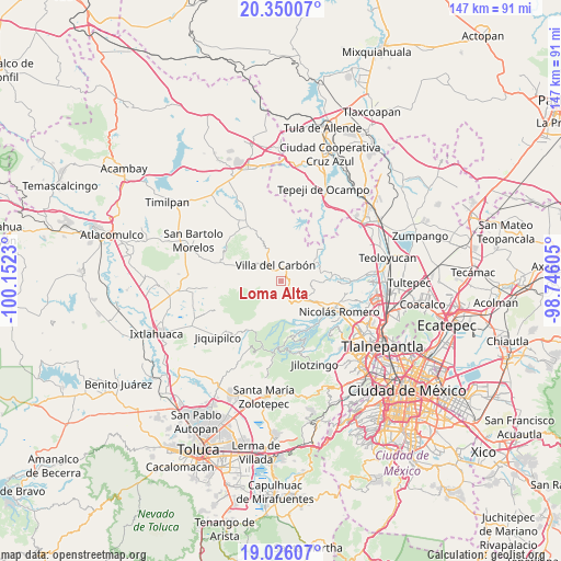
Loma Alta GPS coordinates[2]
19° 41' 21.984" North, 99° 26' 57.012" West
| Map corner | latitude | longitude |
|---|---|---|
| Upper-left | 20.35007°, | -100.1523° |
| Center: | 19.68944°, | -99.44917° |
| Lower-right: | 19.02607°, | -98.74605° |
| Map W x H: | 147.2×147.2 km | = 91.5×91.5mi |
| max Lat: | 32.7° ⇑49.9% North |
| Loma Alta: | 19.68944° |
| min Lat: | ⇓50.1% South 14.53588° |
| min Long | Loma Alta | max Long |
| -117.105° | -99.44917° | -86.73105° |
| W 43.8%⇐ | ⇒56.2% E |
Elevation
Elevation of Loma Alta is 2690 m = 8825 ft, and this is 1436.3 m = 4712 ft above average elevation for this country.
| Max E: |
3497 m = 11473 ft | 2.8% |
| Loma Alta | 2690 m 8825 ft | |
| Avg. | 1253.7 m = 4113 ft | |
Min E: |
-1 m = -3 ft | 97.2% |
See also: Mexico elevation on elevation.city.
Geographical zone
Loma Alta is located in North Torrid zone (between Equator and Tropic of Cancer). Distance of this Northern Tropic circle is 416.7 km =258.9 mi to North.| Distance of | km | miles | from Loma Alta |
|---|---|---|---|
| North Pole | 7817.8 | 4857.8 | to North |
| Arctic Circle | 5211.9 | 3238.5 | to North |
| Tropic Cancer | 416.7 | 258.9 | to North |
| Equator | 2189.3 | 1360.4 | to South |


Nearby cities:
15 places around Loma Alta: (largest is in red/bold)
• El Cerrito
5.3 km =3.3 mi,  264°
264°
• El Ocotal
2.4 km =1.5 mi,  243°
243°
• La Esperanza
7 km =4.3 mi, 264°
• Llano de Zacapexco
4.1 km =2.5 mi,  293°
293°
• Los Arana
6 km =3.7 mi, 292°
• Los Barbechos
3.8 km =2.4 mi, 256°
• Miranda
6 km =3.7 mi,  156°
156°
• Puentecillas Cahuacán
6.3 km =3.9 mi,  175°
175°
• San Isidro del Bosque
6.2 km =3.9 mi,  229°
229°
• San José los Barbechos (Los Barbechos)
5.9 km =3.7 mi,  149°
149°
• San Juan de las Tablas
3.4 km =2.1 mi,  122°
122°
• San Lucas
2.6 km =1.6 mi,  346°
346°
• San Martín Cachihuapan
2.8 km =1.7 mi,  42°
42°
• Santa María Magdalena Cahuacán
6.8 km =4.2 mi, 146°
• Villa del Carbón
4.6 km =2.9 mi,  340°
340°
Sources, notices
• [Note1] Compared only with cities in Mexico existing in our database
• [Src1] Map data: © OpenStreetMap contributors (CC-BY-SA)
• [Src2] Other city data from geonames.org with taken over terms of usage.
• [Src3] Geographical zone / Annual Mean Temperature by Robert A. Rohde @ Wikipedia
