Velasco geodata
Velasco (Hidalgo) is a populated place; located in Mexico in America/Mexico_City (GMT-6) time zone. With population of 562 people, there are 15183 cities with bigger population in this country. Compared to other cities in Mexico, 60.9% of cities are located further ↓South; 55.7% of cities are located further ←West and 90.9% of cities have lower elevation than Velasco. Note1


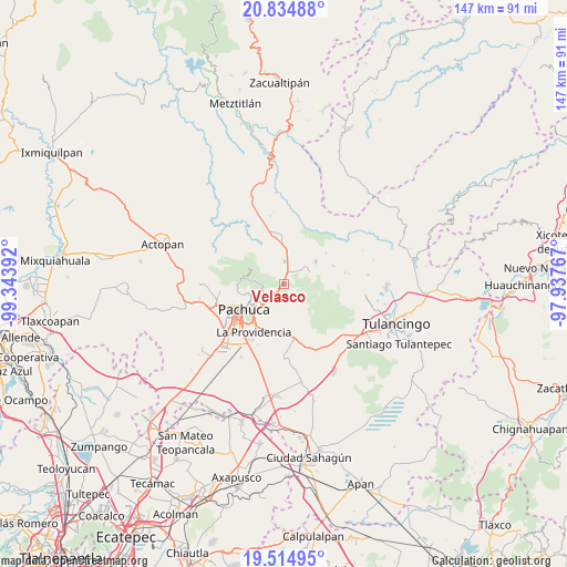
Velasco GPS coordinates[2]
20° 10' 34.716" North, 98° 38' 26.844" West
| Map corner | latitude | longitude |
|---|---|---|
| Upper-left | 20.83488°, | -99.34392° |
| Center: | 20.17631°, | -98.64079° |
| Lower-right: | 19.51495°, | -97.93767° |
| Map W x H: | 146.8×146.8 km | = 91.2×91.2mi |
| max Lat: | 32.7° ⇑39.1% North |
| Velasco: | 20.17631° |
| min Lat: | ⇓60.9% South 14.53588° |
| min Long | Velasco | max Long |
| -117.105° | -98.64079° | -86.73105° |
| W 55.7%⇐ | ⇒44.3% E |
Elevation
Elevation of Velasco is 2438 m = 7999 ft, and this is 1184.3 m = 3885 ft above average elevation for this country.
| Max E: |
3497 m = 11473 ft | 9.1% |
| Velasco | 2438 m 7999 ft | |
| Avg. | 1253.7 m = 4113 ft | |
Min E: |
-1 m = -3 ft | 90.9% |
See also: Mexico elevation on elevation.city.
Geographical zone
Velasco is located in North Torrid zone (between Equator and Tropic of Cancer). Distance of this Northern Tropic circle is 362.5 km =225.2 mi to North.| Distance of | km | miles | from Velasco |
|---|---|---|---|
| North Pole | 7763.7 | 4824.1 | to North |
| Arctic Circle | 5157.8 | 3204.9 | to North |
| Tropic Cancer | 362.5 | 225.2 | to North |
| Equator | 2243.4 | 1394 | to South |


Nearby cities:
15 places around Velasco: (largest is in red/bold)
• Agua Limpia
7.3 km =4.5 mi,  1°
1°
• Camelia (Barrio la Camelia)
9 km =5.6 mi,  250°
250°
• Carboneras
7 km =4.3 mi,  306°
306°
• Huasca de Ocampo
7.4 km =4.6 mi,  65°
65°
• La Loma
7.5 km =4.7 mi,  55°
55°
• Mineral del Monte
5.4 km =3.4 mi,  219°
219°
• Ojo de Agua
8.7 km =5.4 mi,  25°
25°
• Omitlán de Juárez
1.1 km =0.7 mi,  227°
227°
• Pueblo Nuevo
5.2 km =3.2 mi,  266°
266°
• San Antonio el Paso
4.1 km =2.5 mi,  141°
141°
• San Guillermo la Reforma
8.7 km =5.4 mi, 224°
• San José Ocotillos
4.5 km =2.8 mi,  40°
40°
• Santo Tomás Allende
6.6 km =4.1 mi,  20°
20°
• Tezoantla
5.7 km =3.5 mi,  189°
189°
• Venta de Guadalupe
4.6 km =2.9 mi,  359°
359°
Sources, notices
• [Note1] Compared only with cities in Mexico existing in our database
• [Src1] Map data: © OpenStreetMap contributors (CC-BY-SA)
• [Src2] Other city data from geonames.org with taken over terms of usage.
• [Src3] Geographical zone / Annual Mean Temperature by Robert A. Rohde @ Wikipedia
