Carboneras geodata
Carboneras (Hidalgo) is a populated place; located in Mexico in America/Mexico_City (GMT-6) time zone. With population of 1,226 people, there are 7077 cities with bigger population in this country. Compared to other cities in Mexico, 61.7% of cities are located further ↓South; 55.2% of cities are located further ←West and 94.4% of cities have lower elevation than Carboneras. Note1


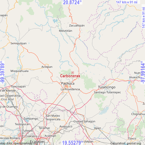
Carboneras GPS coordinates[2]
20° 12' 50.364" North, 98° 41' 41.136" West
| Map corner | latitude | longitude |
|---|---|---|
| Upper-left | 20.8724°, | -99.39789° |
| Center: | 20.21399°, | -98.69476° |
| Lower-right: | 19.55279°, | -97.99164° |
| Map W x H: | 146.7×146.7 km | = 91.2×91.2mi |
| max Lat: | 32.7° ⇑38.3% North |
| Carboneras: | 20.21399° |
| min Lat: | ⇓61.7% South 14.53588° |
| min Long | Carboneras | max Long |
| -117.105° | -98.69476° | -86.73105° |
| W 55.2%⇐ | ⇒44.8% E |
Elevation
Elevation of Carboneras is 2583 m = 8474 ft, and this is 1329.3 m = 4361 ft above average elevation for this country.
| Max E: |
3497 m = 11473 ft | 5.6% |
| Carboneras | 2583 m 8474 ft | |
| Avg. | 1253.7 m = 4113 ft | |
Min E: |
-1 m = -3 ft | 94.4% |
See also: Mexico elevation on elevation.city.
Geographical zone
Carboneras is located in North Torrid zone (between Equator and Tropic of Cancer). Distance of this Northern Tropic circle is 358.3 km =222.6 mi to North.| Distance of | km | miles | from Carboneras |
|---|---|---|---|
| North Pole | 7759.5 | 4821.5 | to North |
| Arctic Circle | 5153.6 | 3202.3 | to North |
| Tropic Cancer | 358.3 | 222.6 | to North |
| Equator | 2247.6 | 1396.6 | to South |


Nearby cities:
15 places around Carboneras: (largest is in red/bold)
• Agua Limpia
6.5 km =4 mi,  61°
61°
• Atotonilco el Grande
8.5 km =5.3 mi,  18°
18°
• Camelia (Barrio la Camelia)
7.8 km =4.8 mi,  201°
201°
• Guadalupe Minerva
10 km =6.2 mi,  191°
191°
• La Estancia
9.5 km =5.9 mi,  3°
3°
• La Estanzuela
7.6 km =4.7 mi,  238°
238°
• La Puebla
7.3 km =4.5 mi, 21°
• Mineral del Monte
8.7 km =5.4 mi,  165°
165°
• Omitlán de Juárez
6.9 km =4.3 mi,  135°
135°
• Pueblo Nuevo
4.6 km =2.9 mi, 174°
• San José Ocotillos
8.6 km =5.3 mi,  95°
95°
• San Miguel Cerezo (El Cerezo)
7 km =4.3 mi,  209°
209°
• Santo Tomás Allende
8.2 km =5.1 mi,  75°
75°
• Velasco
7 km =4.3 mi,  126°
126°
• Venta de Guadalupe
5.6 km =3.5 mi,  85°
85°
Sources, notices
• [Note1] Compared only with cities in Mexico existing in our database
• [Src1] Map data: © OpenStreetMap contributors (CC-BY-SA)
• [Src2] Other city data from geonames.org with taken over terms of usage.
• [Src3] Geographical zone / Annual Mean Temperature by Robert A. Rohde @ Wikipedia
