San José Ocotillos geodata
San José Ocotillos (Hidalgo) is a populated place; located in Mexico in America/Mexico_City (GMT-6) time zone. With population of 1,040 people, there are 8386 cities with bigger population in this country. Compared to other cities in Mexico, 61.5% of cities are located further ↓South; 56% of cities are located further ←West and 87.2% of cities have lower elevation than San José Ocotillos. Note1


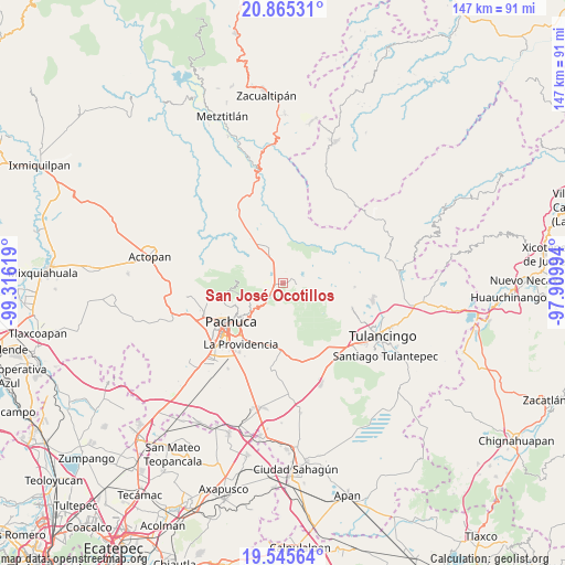
San José Ocotillos GPS coordinates[2]
20° 12' 24.732" North, 98° 36' 47.016" West
| Map corner | latitude | longitude |
|---|---|---|
| Upper-left | 20.86531°, | -99.31619° |
| Center: | 20.20687°, | -98.61306° |
| Lower-right: | 19.54564°, | -97.90994° |
| Map W x H: | 146.7×146.7 km | = 91.2×91.2mi |
| max Lat: | 32.7° ⇑38.5% North |
| San José Ocotillos: | 20.20687° |
| min Lat: | ⇓61.5% South 14.53588° |
| min Long | San José Ocoti | max Long |
| -117.105° | -98.61306° | -86.73105° |
| W 56%⇐ | ⇒44% E |
Elevation
Elevation of San José Ocotillos is 2315 m = 7595 ft, and this is 1061.3 m = 3482 ft above average elevation for this country.
| Max E: |
3497 m = 11473 ft | 12.8% |
| San José Ocotillos | 2315 m 7595 ft | |
| Avg. | 1253.7 m = 4113 ft | |
Min E: |
-1 m = -3 ft | 87.2% |
See also: Mexico elevation on elevation.city.
Geographical zone
San José Ocotillos is located in North Torrid zone (between Equator and Tropic of Cancer). Distance of this Northern Tropic circle is 359.1 km =223.1 mi to North.| Distance of | km | miles | from San José Ocotillos |
|---|---|---|---|
| North Pole | 7760.3 | 4822 | to North |
| Arctic Circle | 5154.4 | 3202.8 | to North |
| Tropic Cancer | 359.1 | 223.1 | to North |
| Equator | 2246.8 | 1396.1 | to South |


Nearby cities:
15 places around San José Ocotillos: (largest is in red/bold)
• Agua Limpia
4.8 km =3 mi,  324°
324°
• Carboneras
8.6 km =5.3 mi,  275°
275°
• Huasca de Ocampo
3.9 km =2.4 mi,  95°
95°
• La Loma
3.4 km =2.1 mi,  74°
74°
• La Puebla
9.6 km =6 mi, 322°
• Montecillos
9.2 km =5.7 mi,  4°
4°
• Ojo de Agua
4.5 km =2.8 mi,  11°
11°
• Omitlán de Juárez
5.5 km =3.4 mi,  221°
221°
• Pueblo Nuevo
8.9 km =5.5 mi,  245°
245°
• San Antonio el Paso
6.6 km =4.1 mi,  182°
182°
• San Miguel Regla
5.6 km =3.5 mi,  75°
75°
• Santo Tomás Allende
2.9 km =1.8 mi,  348°
348°
• Tezoantla
9.8 km =6.1 mi,  202°
202°
• Velasco
4.5 km =2.8 mi, 220°
• Venta de Guadalupe
3.2 km =2 mi,  291°
291°
Sources, notices
• [Note1] Compared only with cities in Mexico existing in our database
• [Src1] Map data: © OpenStreetMap contributors (CC-BY-SA)
• [Src2] Other city data from geonames.org with taken over terms of usage.
• [Src3] Geographical zone / Annual Mean Temperature by Robert A. Rohde @ Wikipedia
