Tzucacab geodata
Tzucacab (Yucatán) is a populated place; located in Mexico in America/Merida (GMT-6) time zone. With population of 9,967 people, there are 955 cities with bigger population in this country. Compared to other cities in Mexico, 58.6% of cities are located further ↓South; 98.7% of cities are located further ←West and 86.3% of cities have higher elevation than Tzucacab. Note1


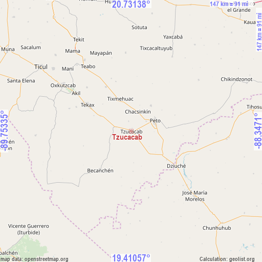
Tzucacab GPS coordinates[2]
20° 4' 20.532" North, 89° 3' 0.792" West
| Map corner | latitude | longitude |
|---|---|---|
| Upper-left | 20.73138°, | -89.75335° |
| Center: | 20.07237°, | -89.05022° |
| Lower-right: | 19.41057°, | -88.3471° |
| Map W x H: | 146.9×146.9 km | = 91.3×91.3mi |
| max Lat: | 32.7° ⇑41.4% North |
| Tzucacab: | 20.07237° |
| min Lat: | ⇓58.6% South 14.53588° |
| min Long | Tzucacab | max Long |
| -117.105° | -89.05022° | -86.73105° |
| W 98.7%⇐ | ⇒1.3% E |
Elevation
Elevation of Tzucacab is 37 m = 121 ft, and this is 1216.7 m = 3992 ft below average elevation for this country.
| Max E: |
3497 m = 11473 ft | 86.3% |
| Avg. | 1253.7 m = 4113 ft | |
| Tzucacab | 37 m = 121 ft | |
Min E: |
-1 m = -3 ft | 13.7% |
See also: Mexico elevation on elevation.city.
Geographical zone
Tzucacab is located in North Torrid zone (between Equator and Tropic of Cancer). Distance of this Northern Tropic circle is 374.1 km =232.5 mi to North.| Distance of | km | miles | from Tzucacab |
|---|---|---|---|
| North Pole | 7775.2 | 4831.3 | to North |
| Arctic Circle | 5169.3 | 3212.1 | to North |
| Tropic Cancer | 374.1 | 232.5 | to North |
| Equator | 2231.8 | 1386.8 | to South |


Nearby cities:
15 places around Tzucacab: (largest is in red/bold)
• Becanchén
28.1 km =17.5 mi,  218°
218°
• Catmis
16.6 km =10.3 mi,  140°
140°
• Chacsinkin
11.6 km =7.2 mi,  17°
17°
• Ek-Balam
5.9 km =3.7 mi,  344°
344°
• Kimbila
25.2 km =15.7 mi,  351°
351°
• Peto
14.7 km =9.1 mi,  65°
65°
• Sabacché
27.1 km =16.8 mi,  5°
5°
• Tahdziu
18.4 km =11.4 mi,  36°
36°
• Tecax
28.6 km =17.8 mi,  301°
301°
• Ticum
19.3 km =12 mi, 296°
• Timul
29 km =18 mi, 23°
• Tixcuytun
22.1 km =13.7 mi,  313°
313°
• Tixmehuac
19.2 km =11.9 mi, 341°
• Xaya
28.7 km =17.8 mi,  330°
330°
• Xoy
10.1 km =6.3 mi,  55°
55°
Sources, notices
• [Note1] Compared only with cities in Mexico existing in our database
• [Src1] Map data: © OpenStreetMap contributors (CC-BY-SA)
• [Src2] Other city data from geonames.org with taken over terms of usage.
• [Src3] Geographical zone / Annual Mean Temperature by Robert A. Rohde @ Wikipedia
