Becanchén geodata
Becanchén (Yucatán) is a populated place; located in Mexico in America/Merida (GMT-6) time zone. With population of 1,713 people, there are 5069 cities with bigger population in this country. Compared to other cities in Mexico, 54.6% of cities are located further ↓South; 98.5% of cities are located further ←West and 77.8% of cities have higher elevation than Becanchén. Note1


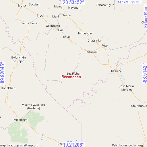
Becanchén GPS coordinates[2]
19° 52' 28.812" North, 89° 13' 2.352" West
| Map corner | latitude | longitude |
|---|---|---|
| Upper-left | 20.53452°, | -89.92045° |
| Center: | 19.87467°, | -89.21732° |
| Lower-right: | 19.21206°, | -88.5142° |
| Map W x H: | 147×147 km | = 91.3×91.3mi |
| max Lat: | 32.7° ⇑45.4% North |
| Becanchén: | 19.87467° |
| min Lat: | ⇓54.6% South 14.53588° |
| min Long | Becanchén | max Long |
| -117.105° | -89.21732° | -86.73105° |
| W 98.5%⇐ | ⇒1.5% E |
Elevation
Elevation of Becanchén is 135 m = 443 ft, and this is 1118.7 m = 3670 ft below average elevation for this country.
| Max E: |
3497 m = 11473 ft | 77.8% |
| Avg. | 1253.7 m = 4113 ft | |
| Becanchén | 135 m = 443 ft | |
Min E: |
-1 m = -3 ft | 22.2% |
See also: Mexico elevation on elevation.city.
Geographical zone
Becanchén is located in North Torrid zone (between Equator and Tropic of Cancer). Distance of this Northern Tropic circle is 396.1 km =246.1 mi to North.| Distance of | km | miles | from Becanchén |
|---|---|---|---|
| North Pole | 7797.2 | 4845 | to North |
| Arctic Circle | 5191.3 | 3225.7 | to North |
| Tropic Cancer | 396.1 | 246.1 | to North |
| Equator | 2209.9 | 1373.2 | to South |


Nearby cities:
15 places around Becanchén: (largest is in red/bold)
• Candelaria
31.1 km =19.3 mi,  119°
119°
• Catmis
29.4 km =18.3 mi,  71°
71°
• Chacsinkin
39.2 km =24.4 mi,  32°
32°
• Ek-Balam
31.9 km =19.8 mi, 29°
• Kancab
38.1 km =23.7 mi,  339°
339°
• Othón P. Blanco
36 km =22.4 mi,  141°
141°
• Puerto Arturo
28.7 km =17.8 mi,  146°
146°
• San Felipe Primero
40.8 km =25.4 mi,  99°
99°
• Tecax
37.4 km =23.2 mi,  349°
349°
• Ticum
30.5 km =19 mi,  0°
0°
• Tixcuytun
37.2 km =23.1 mi, 2°
• Tzucacab
28.1 km =17.5 mi,  38°
38°
• Xohuayan
38.9 km =24.2 mi,  333°
333°
• Xoy
37.8 km =23.5 mi, 42°
• Xul
36 km =22.4 mi,  314°
314°
Sources, notices
• [Note1] Compared only with cities in Mexico existing in our database
• [Src1] Map data: © OpenStreetMap contributors (CC-BY-SA)
• [Src2] Other city data from geonames.org with taken over terms of usage.
• [Src3] Geographical zone / Annual Mean Temperature by Robert A. Rohde @ Wikipedia
