Chacsinkin geodata
Chacsinkin (Yucatán) is a populated place; located in Mexico in America/Merida (GMT-6) time zone. With population of 2,555 people, there are 3464 cities with bigger population in this country. Compared to other cities in Mexico, 60.8% of cities are located further ↓South; 98.8% of cities are located further ←West and 86.1% of cities have higher elevation than Chacsinkin. Note1


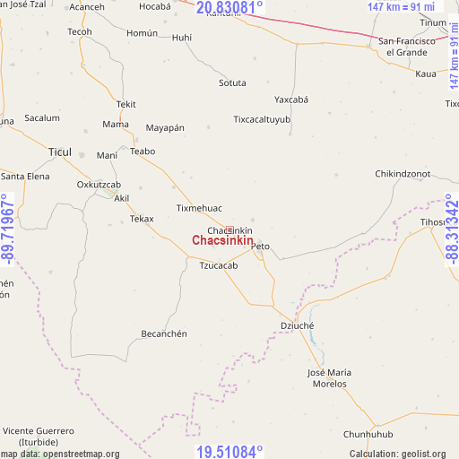
Chacsinkin GPS coordinates[2]
20° 10' 19.992" North, 89° 0' 59.544" West
| Map corner | latitude | longitude |
|---|---|---|
| Upper-left | 20.83081°, | -89.71967° |
| Center: | 20.17222°, | -89.01654° |
| Lower-right: | 19.51084°, | -88.31342° |
| Map W x H: | 146.8×146.8 km | = 91.2×91.2mi |
| max Lat: | 32.7° ⇑39.2% North |
| Chacsinkin: | 20.17222° |
| min Lat: | ⇓60.8% South 14.53588° |
| min Long | Chacsinkin | max Long |
| -117.105° | -89.01654° | -86.73105° |
| W 98.8%⇐ | ⇒1.2% E |
Elevation
Elevation of Chacsinkin is 38 m = 125 ft, and this is 1215.7 m = 3989 ft below average elevation for this country.
| Max E: |
3497 m = 11473 ft | 86.1% |
| Avg. | 1253.7 m = 4113 ft | |
| Chacsinkin | 38 m = 125 ft | |
Min E: |
-1 m = -3 ft | 13.9% |
See also: Mexico elevation on elevation.city.
Geographical zone
Chacsinkin is located in North Torrid zone (between Equator and Tropic of Cancer). Distance of this Northern Tropic circle is 363 km =225.6 mi to North.| Distance of | km | miles | from Chacsinkin |
|---|---|---|---|
| North Pole | 7764.1 | 4824.4 | to North |
| Arctic Circle | 5158.2 | 3205.2 | to North |
| Tropic Cancer | 363 | 225.6 | to North |
| Equator | 2242.9 | 1393.7 | to South |


Nearby cities:
15 places around Chacsinkin: (largest is in red/bold)
• Catmis
24.9 km =15.5 mi,  163°
163°
• Chican
23.7 km =14.7 mi,  321°
321°
• Ek-Balam
7.4 km =4.6 mi,  223°
223°
• Kimbila
15.6 km =9.7 mi,  332°
332°
• Kinil
20.8 km =12.9 mi, 324°
• Peto
11 km =6.8 mi,  116°
116°
• Sabacché
15.9 km =9.9 mi,  355°
355°
• Tahdziu
8.3 km =5.2 mi,  63°
63°
• Ticum
21.1 km =13.1 mi,  262°
262°
• Timul
17.4 km =10.8 mi,  28°
28°
• Tixcuytun
20 km =12.4 mi,  281°
281°
• Tixmehuac
11.9 km =7.4 mi,  306°
306°
• Tzucacab
11.6 km =7.2 mi,  197°
197°
• Xaya
22.5 km =14 mi, 307°
• Xoy
7.2 km =4.5 mi,  138°
138°
Sources, notices
• [Note1] Compared only with cities in Mexico existing in our database
• [Src1] Map data: © OpenStreetMap contributors (CC-BY-SA)
• [Src2] Other city data from geonames.org with taken over terms of usage.
• [Src3] Geographical zone / Annual Mean Temperature by Robert A. Rohde @ Wikipedia
