Totomixtlahuaca geodata
Totomixtlahuaca (Guerrero) is a populated place; located in Mexico in America/Mexico_City (GMT-6) time zone. With population of 1,018 people, there are 8556 cities with bigger population in this country. Compared to other cities in Mexico, 87% of cities are located further ↑North; 53.6% of cities are located further ←West and 62.4% of cities have higher elevation than Totomixtlahuaca. Note1


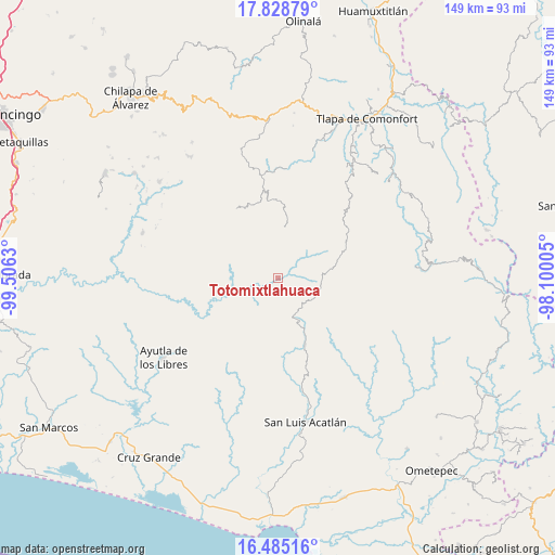
Totomixtlahuaca GPS coordinates[2]
17° 9' 29.484" North, 98° 48' 11.412" West
| Map corner | latitude | longitude |
|---|---|---|
| Upper-left | 17.82879°, | -99.5063° |
| Center: | 17.15819°, | -98.80317° |
| Lower-right: | 16.48516°, | -98.10005° |
| Map W x H: | 149.4×149.4 km | = 92.8×92.8mi |
| max Lat: | 32.7° ⇑87% North |
| Totomixtlahuaca: | 17.15819° |
| min Lat: | ⇓13% South 14.53588° |
| min Long | Totomixtlahuaca | max Long |
| -117.105° | -98.80317° | -86.73105° |
| W 53.6%⇐ | ⇒46.4% E |
Elevation
Elevation of Totomixtlahuaca is 858 m = 2815 ft, and this is 395.7 m = 1298 ft below average elevation for this country.
| Max E: |
3497 m = 11473 ft | 62.4% |
| Avg. | 1253.7 m = 4113 ft | |
| Totomixtlahuaca | 858 m = 2815 ft | |
Min E: |
-1 m = -3 ft | 37.6% |
See also: Mexico elevation on elevation.city.
Geographical zone
Totomixtlahuaca is located in North Torrid zone (between Equator and Tropic of Cancer). Distance of this Northern Tropic circle is 698.1 km =433.8 mi to North.| Distance of | km | miles | from Totomixtlahuaca |
|---|---|---|---|
| North Pole | 8099.3 | 5032.7 | to North |
| Arctic Circle | 5493.4 | 3413.4 | to North |
| Tropic Cancer | 698.1 | 433.8 | to North |
| Equator | 1907.8 | 1185.5 | to South |


Nearby cities:
15 places around Totomixtlahuaca: (largest is in red/bold)
• Apetzuca
15.4 km =9.6 mi,  348°
348°
• Barranca Pobre
13.2 km =8.2 mi,  320°
320°
• Colombia de Guadalupe
9.1 km =5.7 mi,  148°
148°
• El Capulín
14.9 km =9.3 mi,  1°
1°
• El Mirador
10.7 km =6.6 mi,  314°
314°
• El Tejocote
12.7 km =7.9 mi,  358°
358°
• Llano Grande
8.6 km =5.3 mi,  272°
272°
• Mexcaltepec
10.8 km =6.7 mi,  234°
234°
• Paraje Montero (Paraje Montero de Zaragoza)
10.6 km =6.6 mi,  86°
86°
• Pascala del Oro
11.5 km =7.1 mi,  183°
183°
• Tapayoltepec
11.1 km =6.9 mi,  73°
73°
• Tenamazapa
6.9 km =4.3 mi,  339°
339°
• Tilapa
13.4 km =8.3 mi, 154°
• Tlacoapa
13.1 km =8.1 mi,  26°
26°
• Yerba Santa
9.8 km =6.1 mi,  298°
298°
Sources, notices
• [Note1] Compared only with cities in Mexico existing in our database
• [Src1] Map data: © OpenStreetMap contributors (CC-BY-SA)
• [Src2] Other city data from geonames.org with taken over terms of usage.
• [Src3] Geographical zone / Annual Mean Temperature by Robert A. Rohde @ Wikipedia
