Tapayoltepec geodata
Tapayoltepec (Guerrero) is a populated place; located in Mexico in America/Mexico_City (GMT-6) time zone. With population of 510 people, there are 16480 cities with bigger population in this country. Compared to other cities in Mexico, 86.7% of cities are located further ↑North; 55.1% of cities are located further ←West and 71.5% of cities have lower elevation than Tapayoltepec. Note1


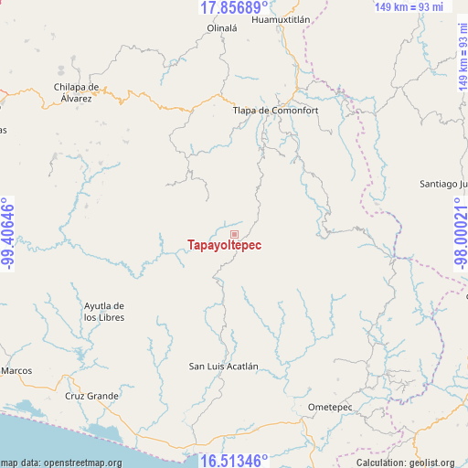
Tapayoltepec GPS coordinates[2]
17° 11' 11.004" North, 98° 42' 11.988" West
| Map corner | latitude | longitude |
|---|---|---|
| Upper-left | 17.85689°, | -99.40646° |
| Center: | 17.18639°, | -98.70333° |
| Lower-right: | 16.51346°, | -98.00021° |
| Map W x H: | 149.4×149.4 km | = 92.8×92.8mi |
| max Lat: | 32.7° ⇑86.7% North |
| Tapayoltepec: | 17.18639° |
| min Lat: | ⇓13.3% South 14.53588° |
| min Long | Tapayoltepec | max Long |
| -117.105° | -98.70333° | -86.73105° |
| W 55.1%⇐ | ⇒44.9% E |
Elevation
Elevation of Tapayoltepec is 1957 m = 6421 ft, and this is 703.3 m = 2307 ft above average elevation for this country.
| Max E: |
3497 m = 11473 ft | 28.5% |
| Tapayoltepec | 1957 m 6421 ft | |
| Avg. | 1253.7 m = 4113 ft | |
Min E: |
-1 m = -3 ft | 71.5% |
See also: Mexico elevation on elevation.city.
Geographical zone
Tapayoltepec is located in North Torrid zone (between Equator and Tropic of Cancer). Distance of this Northern Tropic circle is 695 km =431.9 mi to North.| Distance of | km | miles | from Tapayoltepec |
|---|---|---|---|
| North Pole | 8096.1 | 5030.7 | to North |
| Arctic Circle | 5490.2 | 3411.5 | to North |
| Tropic Cancer | 695 | 431.9 | to North |
| Equator | 1910.9 | 1187.4 | to South |


Nearby cities:
15 places around Tapayoltepec: (largest is in red/bold)
• Aviación
15 km =9.3 mi,  172°
172°
• Cerro Cuate
13.4 km =8.3 mi, 170°
• Colombia de Guadalupe
12.4 km =7.7 mi,  208°
208°
• Cuatzoquitengo
14.7 km =9.1 mi,  39°
39°
• El Capulín
15.5 km =9.6 mi,  319°
319°
• El Tejocote
14.5 km =9 mi,  311°
311°
• Huehuetepec
15 km =9.3 mi,  52°
52°
• Iliatenco
15.8 km =9.8 mi, 173°
• Malinaltepec
7.4 km =4.6 mi,  27°
27°
• Mixtecapa
9.8 km =6.1 mi,  55°
55°
• Ojo de Agua de Cuauhtémoc
5.3 km =3.3 mi,  71°
71°
• Paraje Montero (Paraje Montero de Zaragoza)
2.5 km =1.6 mi,  181°
181°
• Tenamazapa
13.4 km =8.3 mi,  284°
284°
• Tlacoapa
9.8 km =6.1 mi,  330°
330°
• Totomixtlahuaca
11.1 km =6.9 mi,  253°
253°
Sources, notices
• [Note1] Compared only with cities in Mexico existing in our database
• [Src1] Map data: © OpenStreetMap contributors (CC-BY-SA)
• [Src2] Other city data from geonames.org with taken over terms of usage.
• [Src3] Geographical zone / Annual Mean Temperature by Robert A. Rohde @ Wikipedia
