Ahuexotitlán geodata
Ahuexotitlán (Guerrero) is a populated place; located in Mexico in America/Mexico_City (GMT-6) time zone. With population of 1,122 people, there are 7736 cities with bigger population in this country. Compared to other cities in Mexico, 82.9% of cities are located further ↑North; 53.5% of cities are located further →East and 53.2% of cities have lower elevation than Ahuexotitlán. Note1


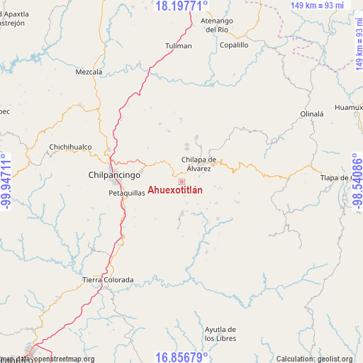
Ahuexotitlán GPS coordinates[2]
17° 31' 42.564" North, 99° 14' 38.328" West
| Map corner | latitude | longitude |
|---|---|---|
| Upper-left | 18.19771°, | -99.94711° |
| Center: | 17.52849°, | -99.24398° |
| Lower-right: | 16.85679°, | -98.54086° |
| Map W x H: | 149.1×149.1 km | = 92.6×92.6mi |
| max Lat: | 32.7° ⇑82.9% North |
| Ahuexotitlán: | 17.52849° |
| min Lat: | ⇓17.1% South 14.53588° |
| min Long | Ahuexotitlán | max Long |
| -117.105° | -99.24398° | -86.73105° |
| W 46.5%⇐ | ⇒53.5% E |
Elevation
Elevation of Ahuexotitlán is 1545 m = 5069 ft, and this is 291.3 m = 956 ft above average elevation for this country.
| Max E: |
3497 m = 11473 ft | 46.8% |
| Ahuexotitlán | 1545 m 5069 ft | |
| Avg. | 1253.7 m = 4113 ft | |
Min E: |
-1 m = -3 ft | 53.2% |
See also: Mexico elevation on elevation.city.
Geographical zone
Ahuexotitlán is located in North Torrid zone (between Equator and Tropic of Cancer). Distance of this Northern Tropic circle is 656.9 km =408.2 mi to North.| Distance of | km | miles | from Ahuexotitlán |
|---|---|---|---|
| North Pole | 8058.1 | 5007.1 | to North |
| Arctic Circle | 5452.2 | 3387.8 | to North |
| Tropic Cancer | 656.9 | 408.2 | to North |
| Equator | 1949 | 1211.1 | to South |


Nearby cities:
15 places around Ahuexotitlán: (largest is in red/bold)
• Acuentla
1.2 km =0.7 mi,  205°
205°
• Axopilco
4.4 km =2.7 mi,  92°
92°
• Chilacachapa
4.8 km =3 mi,  310°
310°
• Coaquimixco
5.7 km =3.5 mi,  8°
8°
• Cuauhtenango
4.4 km =2.7 mi,  63°
63°
• Cuonetzingo
2.3 km =1.4 mi,  266°
266°
• El Durazno
4.9 km =3 mi, 269°
• Los Amates
5.8 km =3.6 mi,  70°
70°
• Popoyatlajco
4.1 km =2.5 mi,  221°
221°
• Santa Ana
5.6 km =3.5 mi,  24°
24°
• Tlacoaxtla
5.4 km =3.4 mi, 57°
• Tlamixtlahuacan
3.4 km =2.1 mi,  145°
145°
• Tlaxinga (Clatzinga)
5.4 km =3.4 mi,  98°
98°
• Tonalapa
4.2 km =2.6 mi,  177°
177°
• Zoquiapa
3.9 km =2.4 mi,  297°
297°
Sources, notices
• [Note1] Compared only with cities in Mexico existing in our database
• [Src1] Map data: © OpenStreetMap contributors (CC-BY-SA)
• [Src2] Other city data from geonames.org with taken over terms of usage.
• [Src3] Geographical zone / Annual Mean Temperature by Robert A. Rohde @ Wikipedia
