Tepexco geodata
Tepexco (Puebla) is a populated place; located in Mexico in America/Mexico_City (GMT-6) time zone. With population of 1,589 people, there are 5433 cities with bigger population in this country. Compared to other cities in Mexico, 70.9% of cities are located further ↑North; 55.2% of cities are located further ←West and 55.1% of cities have higher elevation than Tepexco. Note1


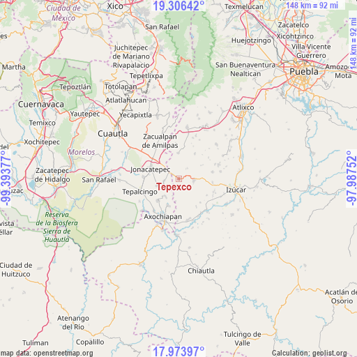
Tepexco GPS coordinates[2]
18° 38' 29.4" North, 98° 41' 26.304" West
| Map corner | latitude | longitude |
|---|---|---|
| Upper-left | 19.30642°, | -99.39377° |
| Center: | 18.6415°, | -98.69064° |
| Lower-right: | 17.97397°, | -97.98752° |
| Map W x H: | 148.2×148.2 km | = 92.1×92.1mi |
| max Lat: | 32.7° ⇑70.9% North |
| Tepexco: | 18.6415° |
| min Lat: | ⇓29.1% South 14.53588° |
| min Long | Tepexco | max Long |
| -117.105° | -98.69064° | -86.73105° |
| W 55.2%⇐ | ⇒44.8% E |
Elevation
Elevation of Tepexco is 1194 m = 3917 ft, and this is 59.7 m = 196 ft below average elevation for this country.
| Max E: |
3497 m = 11473 ft | 55.1% |
| Avg. | 1253.7 m = 4113 ft | |
| Tepexco | 1194 m = 3917 ft | |
Min E: |
-1 m = -3 ft | 44.9% |
See also: Mexico elevation on elevation.city.
Geographical zone
Tepexco is located in North Torrid zone (between Equator and Tropic of Cancer). Distance of this Northern Tropic circle is 533.2 km =331.3 mi to North.| Distance of | km | miles | from Tepexco |
|---|---|---|---|
| North Pole | 7934.3 | 4930.1 | to North |
| Arctic Circle | 5328.4 | 3310.9 | to North |
| Tropic Cancer | 533.2 | 331.3 | to North |
| Equator | 2072.7 | 1287.9 | to South |


Nearby cities:
15 places around Tepexco: (largest is in red/bold)
• Acteopan
13.8 km =8.6 mi,  349°
349°
• Atlacahualoya
12 km =7.5 mi,  200°
200°
• Calmeca
6 km =3.7 mi,  96°
96°
• Chalcatzingo
10.3 km =6.4 mi,  301°
301°
• Jantetelco
12.5 km =7.8 mi,  312°
312°
• Jonacatepec
12.7 km =7.9 mi,  290°
290°
• Los Reyes Teolco
10.9 km =6.8 mi,  357°
357°
• Marcelino Rodríguez (San Ignacio)
8.9 km =5.5 mi,  218°
218°
• San Felipe Tepemaxalco
12.4 km =7.7 mi,  30°
30°
• San Felipe Toctla
13.4 km =8.3 mi, 355°
• San Isidro el Organal
13.7 km =8.5 mi,  148°
148°
• Telixtac
12.8 km =8 mi, 224°
• Temaxcalapa de Gabino Barreda
13.2 km =8.2 mi,  137°
137°
• Tenango
6.8 km =4.2 mi,  251°
251°
• Tetelilla
9.3 km =5.8 mi, 250°
Sources, notices
• [Note1] Compared only with cities in Mexico existing in our database
• [Src1] Map data: © OpenStreetMap contributors (CC-BY-SA)
• [Src2] Other city data from geonames.org with taken over terms of usage.
• [Src3] Geographical zone / Annual Mean Temperature by Robert A. Rohde @ Wikipedia
