Tekanto geodata
Tekanto (Yucatán) is a populated place; located in Mexico in America/Merida (GMT-6) time zone. With population of 3,105 people, there are 2906 cities with bigger population in this country. Compared to other cities in Mexico, 76.6% of cities are located further ↓South; 98.7% of cities are located further ←West and 94% of cities have higher elevation than Tekanto. Note1


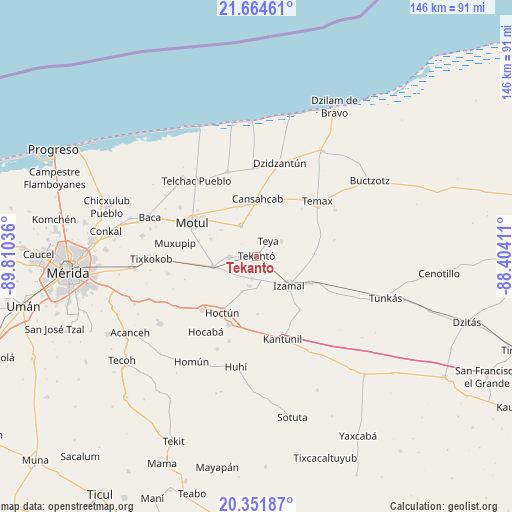
Tekanto GPS coordinates[2]
21° 0' 34.848" North, 89° 6' 26.028" West
| Map corner | latitude | longitude |
|---|---|---|
| Upper-left | 21.66461°, | -89.81036° |
| Center: | 21.00968°, | -89.10723° |
| Lower-right: | 20.35187°, | -88.40411° |
| Map W x H: | 146×146 km | = 90.7×90.7mi |
| max Lat: | 32.7° ⇑23.4% North |
| Tekanto: | 21.00968° |
| min Lat: | ⇓76.6% South 14.53588° |
| min Long | Tekanto | max Long |
| -117.105° | -89.10723° | -86.73105° |
| W 98.7%⇐ | ⇒1.3% E |
Elevation
Elevation of Tekanto is 15 m = 49 ft, and this is 1238.7 m = 4064 ft below average elevation for this country.
| Max E: |
3497 m = 11473 ft | 94% |
| Avg. | 1253.7 m = 4113 ft | |
| Tekanto | 15 m = 49 ft | |
Min E: |
-1 m = -3 ft | 6% |
See also: Mexico elevation on elevation.city.
Geographical zone
Tekanto is located in North Torrid zone (between Equator and Tropic of Cancer). Distance of this Northern Tropic circle is 269.9 km =167.7 mi to North.| Distance of | km | miles | from Tekanto |
|---|---|---|---|
| North Pole | 7671 | 4766.5 | to North |
| Arctic Circle | 5065.1 | 3147.3 | to North |
| Tropic Cancer | 269.9 | 167.7 | to North |
| Equator | 2336.1 | 1451.6 | to South |


Nearby cities:
15 places around Tekanto: (largest is in red/bold)
• Bokoba
7.5 km =4.7 mi,  268°
268°
• Cacalchen
12.8 km =8 mi,  256°
256°
• Cansahcab
16.4 km =10.2 mi,  2°
2°
• Citilcum
6.6 km =4.1 mi,  189°
189°
• Izamal
12.4 km =7.7 mi,  131°
131°
• Kimbila
8.6 km =5.3 mi, 192°
• Kopte
13.8 km =8.6 mi,  291°
291°
• Mesatunych
12.3 km =7.6 mi,  306°
306°
• San José Oriente
16.7 km =10.4 mi,  178°
178°
• San Pedro Chacabal
16.5 km =10.3 mi,  327°
327°
• Sitilpech
17.4 km =10.8 mi,  116°
116°
• Suma de Hidalgo
9.5 km =5.9 mi, 333°
• Tekal de Venegas
16.7 km =10.4 mi,  88°
88°
• Tepakan
8.3 km =5.2 mi,  58°
58°
• Teya
5.8 km =3.6 mi,  37°
37°
Sources, notices
• [Note1] Compared only with cities in Mexico existing in our database
• [Src1] Map data: © OpenStreetMap contributors (CC-BY-SA)
• [Src2] Other city data from geonames.org with taken over terms of usage.
• [Src3] Geographical zone / Annual Mean Temperature by Robert A. Rohde @ Wikipedia
