Sitilpech geodata
Sitilpech (Yucatán) is a populated place; located in Mexico in America/Merida (GMT-6) time zone. With population of 1,799 people, there are 4838 cities with bigger population in this country. Compared to other cities in Mexico, 75.6% of cities are located further ↓South; 98.8% of cities are located further ←West and 92.5% of cities have higher elevation than Sitilpech. Note1


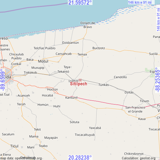
Sitilpech GPS coordinates[2]
20° 56' 25.764" North, 88° 57' 24.372" West
| Map corner | latitude | longitude |
|---|---|---|
| Upper-left | 21.59572°, | -89.6599° |
| Center: | 20.94049°, | -88.95677° |
| Lower-right: | 20.28238°, | -88.25365° |
| Map W x H: | 146×146 km | = 90.7×90.7mi |
| max Lat: | 32.7° ⇑24.4% North |
| Sitilpech: | 20.94049° |
| min Lat: | ⇓75.6% South 14.53588° |
| min Long | Sitilpech | max Long |
| -117.105° | -88.95677° | -86.73105° |
| W 98.8%⇐ | ⇒1.2% E |
Elevation
Elevation of Sitilpech is 18 m = 59 ft, and this is 1235.7 m = 4054 ft below average elevation for this country.
| Max E: |
3497 m = 11473 ft | 92.5% |
| Avg. | 1253.7 m = 4113 ft | |
| Sitilpech | 18 m = 59 ft | |
Min E: |
-1 m = -3 ft | 7.5% |
See also: Mexico elevation on elevation.city.
Geographical zone
Sitilpech is located in North Torrid zone (between Equator and Tropic of Cancer). Distance of this Northern Tropic circle is 277.6 km =172.5 mi to North.| Distance of | km | miles | from Sitilpech |
|---|---|---|---|
| North Pole | 7678.7 | 4771.3 | to North |
| Arctic Circle | 5072.8 | 3152.1 | to North |
| Tropic Cancer | 277.6 | 172.5 | to North |
| Equator | 2328.4 | 1446.8 | to South |


Nearby cities:
15 places around Sitilpech: (largest is in red/bold)
• Citilcum
16.8 km =10.4 mi,  274°
274°
• Cuauhtémoc
7.4 km =4.6 mi,  217°
217°
• Dzoncauich
22.1 km =13.7 mi,  18°
18°
• Holca
20.7 km =12.9 mi,  172°
172°
• Izamal
6.4 km =4 mi,  264°
264°
• Kantunil
18 km =11.2 mi,  207°
207°
• Kimbila
17.5 km =10.9 mi, 267°
• San José Oriente
17.6 km =10.9 mi,  239°
239°
• Sudzal
8.3 km =5.2 mi,  203°
203°
• Tekal de Venegas
8.3 km =5.2 mi,  7°
7°
• Tekanto
17.4 km =10.8 mi,  296°
296°
• Tepakan
14.7 km =9.1 mi,  324°
324°
• Teya
17.2 km =10.7 mi, 315°
• Tunkas
21.7 km =13.5 mi,  101°
101°
• Xanabá
13 km =8.1 mi, 207°
Sources, notices
• [Note1] Compared only with cities in Mexico existing in our database
• [Src1] Map data: © OpenStreetMap contributors (CC-BY-SA)
• [Src2] Other city data from geonames.org with taken over terms of usage.
• [Src3] Geographical zone / Annual Mean Temperature by Robert A. Rohde @ Wikipedia
