Suma de Hidalgo geodata
Suma de Hidalgo (Yucatán) is a populated place; located in Mexico in America/Merida (GMT-6) time zone. With population of 1,861 people, there are 4666 cities with bigger population in this country. Compared to other cities in Mexico, 77.7% of cities are located further ↓South; 98.6% of cities are located further ←West and 96.3% of cities have higher elevation than Suma de Hidalgo. Note1


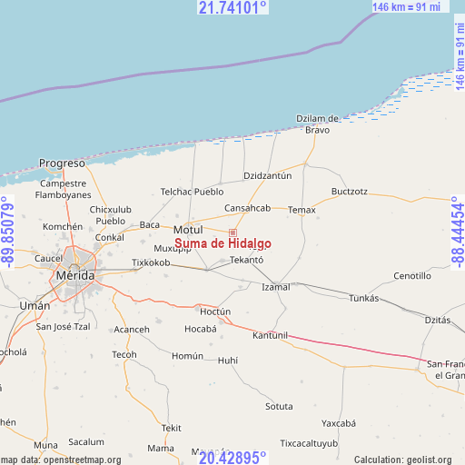
Suma de Hidalgo GPS coordinates[2]
21° 5' 11.148" North, 89° 8' 51.576" West
| Map corner | latitude | longitude |
|---|---|---|
| Upper-left | 21.74101°, | -89.85079° |
| Center: | 21.08643°, | -89.14766° |
| Lower-right: | 20.42895°, | -88.44454° |
| Map W x H: | 145.9×145.9 km | = 90.7×90.7mi |
| max Lat: | 32.7° ⇑22.3% North |
| Suma de Hidalgo: | 21.08643° |
| min Lat: | ⇓77.7% South 14.53588° |
| min Long | Suma de Hidalgo | max Long |
| -117.105° | -89.14766° | -86.73105° |
| W 98.6%⇐ | ⇒1.4% E |
Elevation
Elevation of Suma de Hidalgo is 11 m = 36 ft, and this is 1242.7 m = 4077 ft below average elevation for this country.
| Max E: |
3497 m = 11473 ft | 96.3% |
| Avg. | 1253.7 m = 4113 ft | |
| Suma de Hidalgo | 11 m = 36 ft | |
Min E: |
-1 m = -3 ft | 3.7% |
See also: Mexico elevation on elevation.city.
Geographical zone
Suma de Hidalgo is located in North Torrid zone (between Equator and Tropic of Cancer). Distance of this Northern Tropic circle is 261.3 km =162.4 mi to North.| Distance of | km | miles | from Suma de Hidalgo |
|---|---|---|---|
| North Pole | 7662.5 | 4761.3 | to North |
| Arctic Circle | 5056.6 | 3142 | to North |
| Tropic Cancer | 261.3 | 162.4 | to North |
| Equator | 2344.6 | 1456.9 | to South |


Nearby cities:
15 places around Suma de Hidalgo: (largest is in red/bold)
• Bokoba
9.4 km =5.8 mi,  200°
200°
• Cacalchen
14.1 km =8.8 mi,  215°
215°
• Cansahcab
9.2 km =5.7 mi,  31°
31°
• Citilcum
15.3 km =9.5 mi,  168°
168°
• Kancabal
11.9 km =7.4 mi,  282°
282°
• Kaxatah
11.1 km =6.9 mi,  274°
274°
• Kopte
9.3 km =5.8 mi,  248°
248°
• Mesatunych
5.8 km =3.6 mi,  258°
258°
• Motul
14.1 km =8.8 mi, 274°
• San Pedro Chacabal
7.2 km =4.5 mi,  318°
318°
• Tanya
10.7 km =6.6 mi, 284°
• Tekanto
9.5 km =5.9 mi,  153°
153°
• Tepakan
12.1 km =7.5 mi,  110°
110°
• Teya
8.7 km =5.4 mi,  117°
117°
• Uci
13.3 km =8.3 mi,  289°
289°
Sources, notices
• [Note1] Compared only with cities in Mexico existing in our database
• [Src1] Map data: © OpenStreetMap contributors (CC-BY-SA)
• [Src2] Other city data from geonames.org with taken over terms of usage.
• [Src3] Geographical zone / Annual Mean Temperature by Robert A. Rohde @ Wikipedia
