Izamal geodata
Izamal (Yucatán) is a populated place; located in Mexico in America/Merida (GMT-6) time zone. With population of 16,195 people, there are 593 cities with bigger population in this country. Compared to other cities in Mexico, 75.4% of cities are located further ↓South; 98.7% of cities are located further ←West and 94% of cities have higher elevation than Izamal. Note1


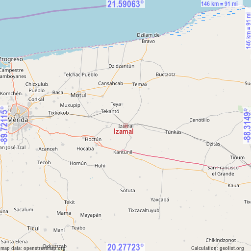
Izamal GPS coordinates[2]
20° 56' 7.332" North, 89° 1' 4.872" West
| Map corner | latitude | longitude |
|---|---|---|
| Upper-left | 21.59063°, | -89.72115° |
| Center: | 20.93537°, | -89.01802° |
| Lower-right: | 20.27723°, | -88.3149° |
| Map W x H: | 146×146 km | = 90.7×90.7mi |
| max Lat: | 32.7° ⇑24.6% North |
| Izamal: | 20.93537° |
| min Lat: | ⇓75.4% South 14.53588° |
| min Long | Izamal | max Long |
| -117.105° | -89.01802° | -86.73105° |
| W 98.7%⇐ | ⇒1.3% E |
Elevation
Elevation of Izamal is 15 m = 49 ft, and this is 1238.7 m = 4064 ft below average elevation for this country.
| Max E: |
3497 m = 11473 ft | 94% |
| Avg. | 1253.7 m = 4113 ft | |
| Izamal | 15 m = 49 ft | |
Min E: |
-1 m = -3 ft | 6% |
See also: Mexico elevation on elevation.city.
Geographical zone
Izamal is located in North Torrid zone (between Equator and Tropic of Cancer). Distance of this Northern Tropic circle is 278.1 km =172.8 mi to North.| Distance of | km | miles | from Izamal |
|---|---|---|---|
| North Pole | 7679.3 | 4771.7 | to North |
| Arctic Circle | 5073.4 | 3152.5 | to North |
| Tropic Cancer | 278.1 | 172.8 | to North |
| Equator | 2327.8 | 1446.4 | to South |


Nearby cities:
15 places around Izamal: (largest is in red/bold)
• Bokoba
18.6 km =11.6 mi,  295°
295°
• Citilcum
10.5 km =6.5 mi,  279°
279°
• Cuauhtémoc
5.6 km =3.5 mi,  160°
160°
• Hoctun
20.6 km =12.8 mi,  247°
247°
• Kantunil
15.6 km =9.7 mi,  186°
186°
• Kimbila
11.1 km =6.9 mi,  269°
269°
• San José Oriente
12.1 km =7.5 mi,  226°
226°
• Sitilpech
6.4 km =4 mi,  84°
84°
• Sudzal
7.6 km =4.7 mi, 156°
• Tekal de Venegas
11.5 km =7.1 mi,  39°
39°
• Tekanto
12.4 km =7.7 mi,  311°
311°
• Tepakan
12.8 km =8 mi,  350°
350°
• Teya
14 km =8.7 mi,  335°
335°
• Xanabá
11 km =6.8 mi,  177°
177°
• Xocchel
20.6 km =12.8 mi,  236°
236°
Sources, notices
• [Note1] Compared only with cities in Mexico existing in our database
• [Src1] Map data: © OpenStreetMap contributors (CC-BY-SA)
• [Src2] Other city data from geonames.org with taken over terms of usage.
• [Src3] Geographical zone / Annual Mean Temperature by Robert A. Rohde @ Wikipedia
