La Candelaria geodata
La Candelaria (Hidalgo) is a populated place; located in Mexico in America/Mexico_City (GMT-6) time zone. With population of 697 people, there are 12494 cities with bigger population in this country. Compared to other cities in Mexico, 69.2% of cities are located further ↓South; 54.3% of cities are located further →East and 57.4% of cities have lower elevation than La Candelaria. Note1


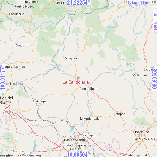
La Candelaria GPS coordinates[2]
20° 33' 56.376" North, 99° 18' 31.104" West
| Map corner | latitude | longitude |
|---|---|---|
| Upper-left | 21.22254°, | -100.01177° |
| Center: | 20.56566°, | -99.30864° |
| Lower-right: | 19.90594°, | -98.60552° |
| Map W x H: | 146.4×146.4 km | = 91×91mi |
| max Lat: | 32.7° ⇑30.8% North |
| La Candelaria: | 20.56566° |
| min Lat: | ⇓69.2% South 14.53588° |
| min Long | La Candelaria | max Long |
| -117.105° | -99.30864° | -86.73105° |
| W 45.7%⇐ | ⇒54.3% E |
Elevation
Elevation of La Candelaria is 1675 m = 5495 ft, and this is 421.3 m = 1382 ft above average elevation for this country.
| Max E: |
3497 m = 11473 ft | 42.6% |
| La Candelaria | 1675 m 5495 ft | |
| Avg. | 1253.7 m = 4113 ft | |
Min E: |
-1 m = -3 ft | 57.4% |
See also: Mexico elevation on elevation.city.
Geographical zone
La Candelaria is located in North Torrid zone (between Equator and Tropic of Cancer). Distance of this Northern Tropic circle is 319.2 km =198.3 mi to North.| Distance of | km | miles | from La Candelaria |
|---|---|---|---|
| North Pole | 7720.4 | 4797.2 | to North |
| Arctic Circle | 5114.5 | 3178 | to North |
| Tropic Cancer | 319.2 | 198.3 | to North |
| Equator | 2286.7 | 1420.9 | to South |


Nearby cities:
15 places around La Candelaria: (largest is in red/bold)
• Arbolado
1.6 km =1 mi,  259°
259°
• Bondhí
3.9 km =2.4 mi,  159°
159°
• Caltimacan
7.2 km =4.5 mi,  243°
243°
• Danghu
7.8 km =4.8 mi,  211°
211°
• El Durazno
9.9 km =6.2 mi,  112°
112°
• El Déxtho
8 km =5 mi,  148°
148°
• Ignacio López Rayón
9.8 km =6.1 mi, 155°
• Juchitlán
2.9 km =1.8 mi,  132°
132°
• La Heredad
9.9 km =6.2 mi, 126°
• La Vega
8.5 km =5.3 mi,  194°
194°
• Portezuelo
8.8 km =5.5 mi,  178°
178°
• San Isidro
2.7 km =1.7 mi,  215°
215°
• San Juanico
7.7 km =4.8 mi,  117°
117°
• Santiago Ixtlahuaca
7.6 km =4.7 mi, 189°
• Tasquillo
2 km =1.2 mi, 194°
Sources, notices
• [Note1] Compared only with cities in Mexico existing in our database
• [Src1] Map data: © OpenStreetMap contributors (CC-BY-SA)
• [Src2] Other city data from geonames.org with taken over terms of usage.
• [Src3] Geographical zone / Annual Mean Temperature by Robert A. Rohde @ Wikipedia
