Taxco geodata
Taxco (Tabasco) is a populated place; located in Mexico in America/Mexico_City (GMT-6) time zone. With population of 2,016 people, there are 4316 cities with bigger population in this country. Compared to other cities in Mexico, 77.1% of cities are located further ↑North; 88.5% of cities are located further ←West and 97.5% of cities have higher elevation than Taxco. Note1


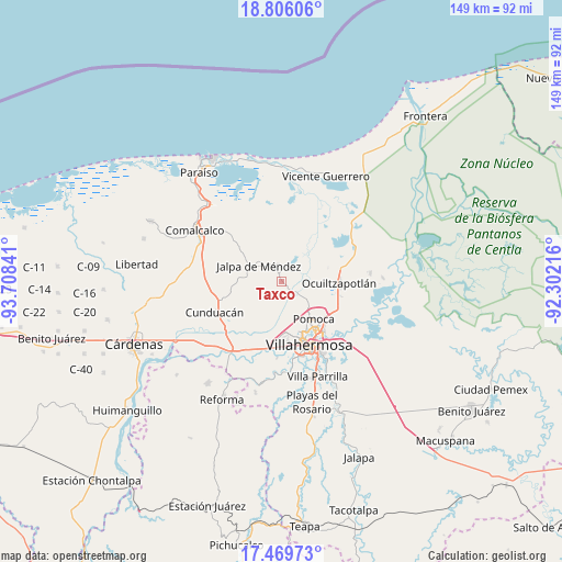
Taxco GPS coordinates[2]
18° 8' 21.012" North, 93° 0' 19.008" West
| Map corner | latitude | longitude |
|---|---|---|
| Upper-left | 18.80606°, | -93.70841° |
| Center: | 18.13917°, | -93.00528° |
| Lower-right: | 17.46973°, | -92.30216° |
| Map W x H: | 148.6×148.6 km | = 92.3×92.3mi |
| max Lat: | 32.7° ⇑77.1% North |
| Taxco: | 18.13917° |
| min Lat: | ⇓22.9% South 14.53588° |
| min Long | Taxco | max Long |
| -117.105° | -93.00528° | -86.73105° |
| W 88.5%⇐ | ⇒11.5% E |
Elevation
Elevation of Taxco is 9 m = 30 ft, and this is 1244.7 m = 4084 ft below average elevation for this country.
| Max E: |
3497 m = 11473 ft | 97.5% |
| Avg. | 1253.7 m = 4113 ft | |
| Taxco | 9 m = 30 ft | |
Min E: |
-1 m = -3 ft | 2.5% |
See also: Mexico elevation on elevation.city.
Geographical zone
Taxco is located in North Torrid zone (between Equator and Tropic of Cancer). Distance of this Northern Tropic circle is 589 km =366 mi to North.| Distance of | km | miles | from Taxco |
|---|---|---|---|
| North Pole | 7990.2 | 4964.9 | to North |
| Arctic Circle | 5384.3 | 3345.6 | to North |
| Tropic Cancer | 589 | 366 | to North |
| Equator | 2016.9 | 1253.2 | to South |


Nearby cities:
15 places around Taxco: (largest is in red/bold)
• Corriente 1ra. Sección
2.4 km =1.5 mi,  30°
30°
• El Tigre
7.9 km =4.9 mi,  121°
121°
• El Zapote
5.4 km =3.4 mi,  76°
76°
• Guatacalca
4.1 km =2.5 mi,  43°
43°
• Jalpa de Méndez
7.4 km =4.6 mi,  304°
304°
• Jalupa
4.2 km =2.6 mi,  266°
266°
• Jiménez
8 km =5 mi,  72°
72°
• La Cruz
2.7 km =1.7 mi,  257°
257°
• Mazateupa
7 km =4.3 mi,  356°
356°
• Nacajuca
3.7 km =2.3 mi,  337°
337°
• Nicolás Bravo
8.4 km =5.2 mi,  282°
282°
• Olcuatitán
7.4 km =4.6 mi, 39°
• Tapotzingo
7.3 km =4.5 mi,  352°
352°
• Tierras Peleadas (Tierras Amigas)
3.4 km =2.1 mi, 282°
• Tucta
6.1 km =3.8 mi,  9°
9°
Sources, notices
• [Note1] Compared only with cities in Mexico existing in our database
• [Src1] Map data: © OpenStreetMap contributors (CC-BY-SA)
• [Src2] Other city data from geonames.org with taken over terms of usage.
• [Src3] Geographical zone / Annual Mean Temperature by Robert A. Rohde @ Wikipedia
