Tanya geodata
Tanya (Yucatán) is a populated place; located in Mexico in America/Merida (GMT-6) time zone. With population of 879 people, there are 9939 cities with bigger population in this country. Compared to other cities in Mexico, 78% of cities are located further ↓South; 98.5% of cities are located further ←West and 95.7% of cities have higher elevation than Tanya. Note1


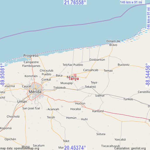
Tanya GPS coordinates[2]
21° 6' 39.996" North, 89° 14' 51.648" West
| Map corner | latitude | longitude |
|---|---|---|
| Upper-left | 21.76558°, | -89.95081° |
| Center: | 21.11111°, | -89.24768° |
| Lower-right: | 20.45374°, | -88.54456° |
| Map W x H: | 145.9×145.9 km | = 90.7×90.7mi |
| max Lat: | 32.7° ⇑22% North |
| Tanya: | 21.11111° |
| min Lat: | ⇓78% South 14.53588° |
| min Long | Tanya | max Long |
| -117.105° | -89.24768° | -86.73105° |
| W 98.5%⇐ | ⇒1.5% E |
Elevation
Elevation of Tanya is 12 m = 39 ft, and this is 1241.7 m = 4074 ft below average elevation for this country.
| Max E: |
3497 m = 11473 ft | 95.7% |
| Avg. | 1253.7 m = 4113 ft | |
| Tanya | 12 m = 39 ft | |
Min E: |
-1 m = -3 ft | 4.3% |
See also: Mexico elevation on elevation.city.
Geographical zone
Tanya is located in North Torrid zone (between Equator and Tropic of Cancer). Distance of this Northern Tropic circle is 258.6 km =160.7 mi to North.| Distance of | km | miles | from Tanya |
|---|---|---|---|
| North Pole | 7659.7 | 4759.5 | to North |
| Arctic Circle | 5053.8 | 3140.3 | to North |
| Tropic Cancer | 258.6 | 160.7 | to North |
| Equator | 2347.3 | 1458.5 | to South |


Nearby cities:
15 places around Tanya: (largest is in red/bold)
• Bokoba
13.5 km =8.4 mi,  148°
148°
• Cholul Cantón
12 km =7.5 mi,  202°
202°
• Dzemul
12.8 km =8 mi,  329°
329°
• Kancabal
1.2 km =0.7 mi,  262°
262°
• Kaxatah
1.9 km =1.2 mi, 199°
• Kini
7.7 km =4.8 mi,  290°
290°
• Kopte
6.4 km =4 mi,  164°
164°
• Mesatunych
6.1 km =3.8 mi,  129°
129°
• Motul
4.1 km =2.5 mi,  245°
245°
• Muxupip
11.4 km =7.1 mi,  227°
227°
• Sacapuc
12.7 km =7.9 mi,  298°
298°
• San Pedro Chacabal
6.3 km =3.9 mi,  64°
64°
• Suma de Hidalgo
10.7 km =6.6 mi,  104°
104°
• Telchac Pueblo
10.5 km =6.5 mi,  347°
347°
• Uci
2.8 km =1.7 mi,  309°
309°
Sources, notices
• [Note1] Compared only with cities in Mexico existing in our database
• [Src1] Map data: © OpenStreetMap contributors (CC-BY-SA)
• [Src2] Other city data from geonames.org with taken over terms of usage.
• [Src3] Geographical zone / Annual Mean Temperature by Robert A. Rohde @ Wikipedia
