Uci geodata
Uci (Yucatán) is a populated place; located in Mexico in America/Merida (GMT-6) time zone. With population of 1,224 people, there are 7093 cities with bigger population in this country. Compared to other cities in Mexico, 78.2% of cities are located further ↓South; 98.5% of cities are located further ←West and 97% of cities have higher elevation than Uci. Note1


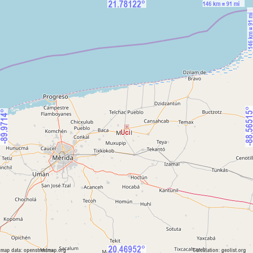
Uci GPS coordinates[2]
21° 7' 36.552" North, 89° 16' 5.772" West
| Map corner | latitude | longitude |
|---|---|---|
| Upper-left | 21.78122°, | -89.9714° |
| Center: | 21.12682°, | -89.26827° |
| Lower-right: | 20.46952°, | -88.56515° |
| Map W x H: | 145.8×145.9 km | = 90.6×90.7mi |
| max Lat: | 32.7° ⇑21.8% North |
| Uci: | 21.12682° |
| min Lat: | ⇓78.2% South 14.53588° |
| min Long | Uci | max Long |
| -117.105° | -89.26827° | -86.73105° |
| W 98.5%⇐ | ⇒1.5% E |
Elevation
Elevation of Uci is 10 m = 33 ft, and this is 1243.7 m = 4080 ft below average elevation for this country.
| Max E: |
3497 m = 11473 ft | 97% |
| Avg. | 1253.7 m = 4113 ft | |
| Uci | 10 m = 33 ft | |
Min E: |
-1 m = -3 ft | 3% |
See also: Mexico elevation on elevation.city.
Geographical zone
Uci is located in North Torrid zone (between Equator and Tropic of Cancer). Distance of this Northern Tropic circle is 256.8 km =159.6 mi to North.| Distance of | km | miles | from Uci |
|---|---|---|---|
| North Pole | 7658 | 4758.5 | to North |
| Arctic Circle | 5052.1 | 3139.2 | to North |
| Tropic Cancer | 256.8 | 159.6 | to North |
| Equator | 2349.1 | 1459.7 | to South |


Nearby cities:
15 places around Uci: (largest is in red/bold)
• Baca
13.7 km =8.5 mi,  261°
261°
• Cholul Cantón
13.1 km =8.1 mi,  190°
190°
• Dzemul
10.2 km =6.3 mi,  335°
335°
• Kancabal
2.1 km =1.3 mi,  154°
154°
• Kaxatah
3.8 km =2.4 mi,  157°
157°
• Kini
5.1 km =3.2 mi,  280°
280°
• Kopte
8.8 km =5.5 mi, 153°
• Mesatunych
8.8 km =5.5 mi,  129°
129°
• Motul
3.8 km =2.4 mi,  204°
204°
• Muxupip
11.3 km =7 mi,  213°
213°
• Sacapuc
10 km =6.2 mi,  295°
295°
• San Pedro Chacabal
7.8 km =4.8 mi,  83°
83°
• Suma de Hidalgo
13.3 km =8.3 mi,  109°
109°
• Tanya
2.8 km =1.7 mi, 129°
• Telchac Pueblo
8.5 km =5.3 mi,  359°
359°
Sources, notices
• [Note1] Compared only with cities in Mexico existing in our database
• [Src1] Map data: © OpenStreetMap contributors (CC-BY-SA)
• [Src2] Other city data from geonames.org with taken over terms of usage.
• [Src3] Geographical zone / Annual Mean Temperature by Robert A. Rohde @ Wikipedia
