Dzemul geodata
Dzemul (Yucatán) is a populated place; located in Mexico in America/Merida (GMT-6) time zone. With population of 3,228 people, there are 2806 cities with bigger population in this country. Compared to other cities in Mexico, 79.2% of cities are located further ↓South; 98.4% of cities are located further ←West and 95.7% of cities have higher elevation than Dzemul. Note1


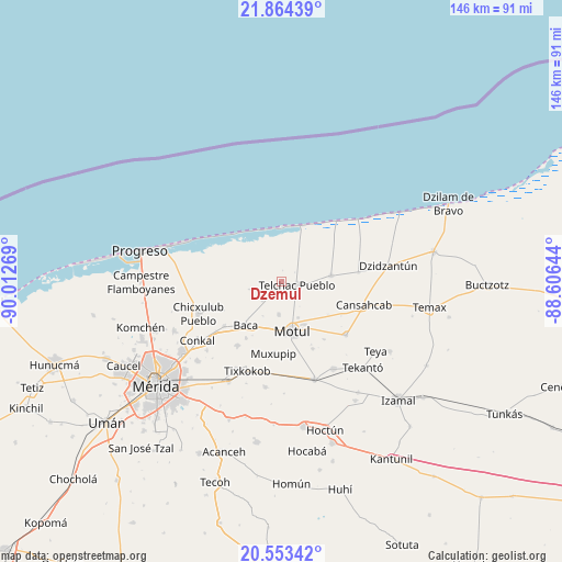
Dzemul GPS coordinates[2]
21° 12' 37.296" North, 89° 18' 34.416" West
| Map corner | latitude | longitude |
|---|---|---|
| Upper-left | 21.86439°, | -90.01269° |
| Center: | 21.21036°, | -89.30956° |
| Lower-right: | 20.55342°, | -88.60644° |
| Map W x H: | 145.8×145.8 km | = 90.6×90.6mi |
| max Lat: | 32.7° ⇑20.8% North |
| Dzemul: | 21.21036° |
| min Lat: | ⇓79.2% South 14.53588° |
| min Long | Dzemul | max Long |
| -117.105° | -89.30956° | -86.73105° |
| W 98.4%⇐ | ⇒1.6% E |
Elevation
Elevation of Dzemul is 12 m = 39 ft, and this is 1241.7 m = 4074 ft below average elevation for this country.
| Max E: |
3497 m = 11473 ft | 95.7% |
| Avg. | 1253.7 m = 4113 ft | |
| Dzemul | 12 m = 39 ft | |
Min E: |
-1 m = -3 ft | 4.3% |
See also: Mexico elevation on elevation.city.
Geographical zone
Dzemul is located in North Torrid zone (between Equator and Tropic of Cancer). Distance of this Northern Tropic circle is 247.5 km =153.8 mi to North.| Distance of | km | miles | from Dzemul |
|---|---|---|---|
| North Pole | 7648.7 | 4752.7 | to North |
| Arctic Circle | 5042.8 | 3133.4 | to North |
| Tropic Cancer | 247.5 | 153.8 | to North |
| Equator | 2358.4 | 1465.4 | to South |


Nearby cities:
15 places around Dzemul: (largest is in red/bold)
• Baca
14.6 km =9.1 mi,  219°
219°
• Kancabal
12.3 km =7.6 mi,  155°
155°
• Kaxatah
14.1 km =8.8 mi, 155°
• Kini
8.4 km =5.2 mi,  185°
185°
• Mesatunych
18.6 km =11.6 mi,  143°
143°
• Motul
13 km =8.1 mi,  167°
167°
• Sacapuc
6.9 km =4.3 mi, 223°
• San Pedro Chacabal
14.7 km =9.1 mi,  124°
124°
• Sinanche
13 km =8.1 mi,  82°
82°
• Tanya
12.8 km =8 mi,  149°
149°
• Telchac Pueblo
4.2 km =2.6 mi,  100°
100°
• Telchac Puerto
15.3 km =9.5 mi,  18°
18°
• Timul
8.6 km =5.3 mi,  257°
257°
• Tixkunchell
17.1 km =10.6 mi,  212°
212°
• Uci
10.2 km =6.3 mi, 155°
Sources, notices
• [Note1] Compared only with cities in Mexico existing in our database
• [Src1] Map data: © OpenStreetMap contributors (CC-BY-SA)
• [Src2] Other city data from geonames.org with taken over terms of usage.
• [Src3] Geographical zone / Annual Mean Temperature by Robert A. Rohde @ Wikipedia
