Seyé geodata
Seyé (Yucatán) is a seat of a second-order administrative division; located in Mexico in America/Merida (GMT-6) time zone. With population of 8,369 people, there are 1139 cities with bigger population in this country. Compared to other cities in Mexico, 73.8% of cities are located further ↓South; 98.3% of cities are located further ←West and 92.1% of cities have higher elevation than Seyé. Note1


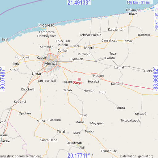
Seyé GPS coordinates[2]
20° 50' 8.448" North, 89° 22' 18.264" West
| Map corner | latitude | longitude |
|---|---|---|
| Upper-left | 21.49138°, | -90.07487° |
| Center: | 20.83568°, | -89.37174° |
| Lower-right: | 20.17711°, | -88.66862° |
| Map W x H: | 146.1×146.1 km | = 90.8×90.8mi |
| max Lat: | 32.7° ⇑26.2% North |
| Seyé: | 20.83568° |
| min Lat: | ⇓73.8% South 14.53588° |
| min Long | Seyé | max Long |
| -117.105° | -89.37174° | -86.73105° |
| W 98.3%⇐ | ⇒1.7% E |
Elevation
Elevation of Seyé is 19 m = 62 ft, and this is 1234.7 m = 4051 ft below average elevation for this country.
| Max E: |
3497 m = 11473 ft | 92.1% |
| Avg. | 1253.7 m = 4113 ft | |
| Seyé | 19 m = 62 ft | |
Min E: |
-1 m = -3 ft | 7.9% |
See also: Mexico elevation on elevation.city.
Geographical zone
Seyé is located in North Torrid zone (between Equator and Tropic of Cancer). Distance of this Northern Tropic circle is 289.2 km =179.7 mi to North.| Distance of | km | miles | from Seyé |
|---|---|---|---|
| North Pole | 7690.4 | 4778.6 | to North |
| Arctic Circle | 5084.5 | 3159.4 | to North |
| Tropic Cancer | 289.2 | 179.7 | to North |
| Equator | 2316.7 | 1439.5 | to South |


Nearby cities:
15 places around Seyé: (largest is in red/bold)
• Acanceh
8.8 km =5.5 mi,  253°
253°
• Canícab
6.8 km =4.2 mi,  293°
293°
• Cuzama
11.9 km =7.4 mi,  151°
151°
• Ekmul
14.5 km =9 mi,  8°
8°
• Eknakan
8.7 km =5.4 mi,  178°
178°
• Hocaba
13.2 km =8.2 mi,  99°
99°
• Holactun
6.4 km =4 mi,  44°
44°
• Homun
14 km =8.7 mi,  139°
139°
• Petectunich
10.9 km =6.8 mi,  273°
273°
• Sahé
13.4 km =8.3 mi,  315°
315°
• Tahmek
12.9 km =8 mi,  70°
70°
• Tekoh
14.8 km =9.2 mi,  226°
226°
• Tepich Carrillo
13.9 km =8.6 mi, 289°
• Ticopó
9.3 km =5.8 mi,  309°
309°
• Timucuy
15 km =9.3 mi,  259°
259°
Sources, notices
• [Note1] Compared only with cities in Mexico existing in our database
• [Src1] Map data: © OpenStreetMap contributors (CC-BY-SA)
• [Src2] Other city data from geonames.org with taken over terms of usage.
• [Src3] Geographical zone / Annual Mean Temperature by Robert A. Rohde @ Wikipedia
